Moncreiffe Hill
By Colin Hogarth
Moncreiffe Hill, to the south of Perth, is a familiar landmark for anyone heading north on the M90. The motorway nudges the craggy slopes but within the tranquil wooded enclave you could be a million miles from the hustle and bustle of the heavy traffic so close at hand.
Walkers are welcome to explore the 333 acres of mixed broadleaf and conifer forest on the south side of the hill which was bought by the Woodland Trust, a conservation body, in 1988. Subsequent studies have identified over 100 species of plant and animal and bird life to look out for, including red squirrels, green woodpeckers and buzzards.
This route climbs from the base of the hill through the trees to emerge at the highest point where there are panoramic views to savour. Head up to a wooden gate and information board at the top end of the car park. Pass through the gate and a path climbs steadily through the trees to a junction.
Turn right here and the route continues to climb, curving right and then left to another junction where a grassy track heads west through the forest. Don't take this but bear right instead, staying with the main track as it rises through a mix of coniferous trees, oak and sycamore, the grassy forest floor dotted with pink foxgloves.
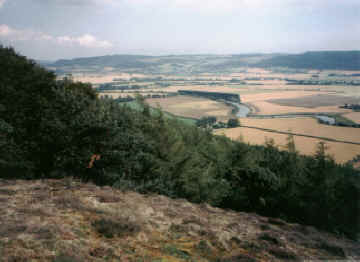
The track curves left as it gains height and the gradient eases off to run almost level through the trees, emerging at an open viewpoint. Rest for a moment in the purple heather and enjoy spectacular vistas south over the River Earn to the Ochil Hills and the Lomond Hills beyond.
Bridge of Earn is clearly visible hugging the banks of the meandering River Earn below, while Abernethy can be seen to the south east, its historic tower poking out above the tiny houses.
The path disappears into the trees again, descending slightly before widening into a track to run level along the hillside. Stay with this until you reach an obvious grassy path on the right. This curves up on to the summit of the hill - Moredun Top - which is another fine viewpoint, this time offering panoramas north to Perth and east over the River Tay and Carse of Gowrie.
From the cairn, a narrow path drops over the west side of the hill to rejoin the ascent path at a junction. Instead of heading back to the original track, turn right and another track descends to a viewpoint with bench, just a short detour away.
The track then curves left round the hillside and descends to a wide junction. Take the right-hand option here and the way drops through mixed woodland, skirting along the edge of an open field, and curves to the left to reach its terminus above a wooden gate.
Carry straight on along a narrow path through the grass to a wooden fence where the way bears left and follows the fence down through the trees and continues on to join a track just above the motorway.
Turn left and the track climbs gently through the trees, eventually reaching the junction at the top of the track from the car park. Retrace steps down the hill from here.
WALK FACTS
Distance 5 miles/8km.
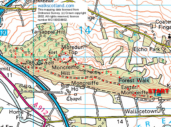
Map OS Landranger 1:50,000 sheet 58.
Start/parking Woodland Trust car park (grid ref NO 154193). To reach this follow the A912 out of Bridge of Earn and, immediately on the other side of the bridge over the River Earn, turn right and follow the minor road east under the motorway. A mile and a half on a sign points left up a track to the car park.
Grading Easy forest walk for all the family.