On St Cuthbert's Way
By Colin Hogarth
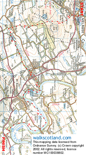
St Cuthbert's Way is a long distance route snaking through Border country from Melrose to Holy Island on the Northumberland coast. It links many historic sites associated with the former Bishop of Lindisfarne and there's a healthy collection of Roman remains along the way. Hearty walkers can trek the entire route in as little as four days but the proximity of towns and villages with good public transport links and fine hotels makes it possible to break it down into a series of less strenuous days out. As a taster, why not try the first section, from Melrose to the pretty hamlet of Maxton?
The tourist information centre next to Melrose Abbey is a good starting point for the walk. Before you set off, it's worth popping into the abbey for a taste of the area's religious background. It was built by Cistercian monks in 1136 and, although badly damaged by English attacks during the 14th century, part of the original church still stands.
The way leaves the charming if chaotic town square and follows the road under the A6091 Melrose bypass. A short way on, to the left, steps drop down between two houses and a path climbs on to the Eildon Hills. It skirts between fields and then rises between two of the summits.
From the pass, the path descends to lush green woodland where tall beech and pine trees throw a leafy canopy over the carpet of bracken and wildflowers. Continue down and the way skirts the bottom of the plantation to emerge at a farm track. Cross and it climbs through a small woodland to reach the peaceful village of Bowden.
This is a particularly pretty community where quaint cottages cluster along the tree-lined main street. Go over the main road by the tiny Post Office and a narrow road to the leads down to a riverside path running east through a delightfully secluded valley. It reaches a farm steading at Whitelee and a quiet stretch of country road leads from here into Newton St Boswells.
Put the houses behind you and a real treat awaits - the River Tweed. It arrives on the scene as if by accident. The path losses itself in dense shrubbery after passing beneath the busy A68 and, when you least expect it, hurls you out on to one of the most spectacular viewpoints in the Scottish Borders. A deep blue river vista stretches away below, the Eildon Hills offering the dramatic backdrop for a scene well worth capturing on camera.
The path follows the river for the next stretch and you may be lucky enough to see heron fishing alongside the many ducks. An impressive suspension bridge offers access to Dryburgh Abbey. Here you'll find the graves of Sir Walter Scott, who died at Abbotsford in 1832, and First World War commander Earl Haig.
The way loops round to the bustling community of St Boswells and another peaceful riverside walk, part of it alongside a golf course, leads to Maxton and its unspoiled village kirk and graveyard.
WALK FACTS
Distance 10 miles/16km.
Map OS Landranger sheets 73 and 74. Harvey's St Cuthbert's Way.
Start/parking Tourist information centre next to Melrose Abbey, Melrose. GR: NT 547342. There is parking available in the centre of Melrose.
Grading Low level route with path and track throughout suitable for reasonably fit adults and older children. This is a linear route, but there is a good public bus service. Pop into the tourist information centre before you set off - they have timetables.