Roam to the Red Well
By James Carron
The town of Newtonmore sits in Badenoch, the geographical centre of Scotland. Shadowed by the Monadhliath Mountains, walking opportunities abound and every effort is being made locally to encourage this past-time.
From the well-served centre of the town, it is only a matter of minutes before you are out in open country, heading across vast, empty moorlands where you can go for hours without bumping into another person. If you're really lucky, you may see the elusive wildcat. Up in such remote country, it's easy to spot deer roaming the hillsides, or to perhaps surprise Black Grouse nestling peacefully in the heather. This route weaves through just such a landscape, skirting by crisp, cool mountain streams and returning through a wonderful mixed woodland, which is in the process of being extended.
From the Church of Scotland, head east along the road immediately in front of the place of worship, Church Terrace, passing between houses, then take a left up a track which goes by a boarded up cottage, then narrows into a path, leading to a children's playpark. As this is reached, bear right up a paved path, which skirts the play area to reach Clune Terrace. Turn right and follow the street of white-washed local authority houses east to a BT phone box. Turn left here, following a single-track road up between open fields, crossing a cattlegrid. Stay with the road as it curves right, then left at a steading.
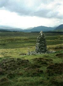
Further on, the road swings right again, in front of a derelict cottage and continues to Strone, a pair of houses straddling the way. Continue for 200 yards from here. When you reach a rundown stone barn on the left, leave the road and turn left on to a track. This passes through a gate a few yards on and heads over open moorland, often used for sheep grazing. Ignore a waymarked path bisecting the track and continue north. Three quarters of a mile from the start of the track, it fords a stream (there are stepping-stones) and bears right. Continue on to reach a gate, shortly after two large stone cairns.
From the gate, walk north to meet up with the Allt na Beinne. The route bears right here and follows the burn upstream, through a narrow glen carpeted in bracken and purple heather. The way starts to climb quite steeply, passing the site of a now demolished shelter known as the Green Bothy. It pulls out of the valley on to open hillside above and you should continue for a quarter of a mile to reach the Red Well. The well is obvious, down to the left of the track. It sits just above the burn and is so called because the soil around it as been dyed a red-brown colour by the iron in the water. Turn round here and follow the track back down to the point where it originally met up with the Allt na Beinne.
Leave the track as it starts to veer away from the burn. Turn right and cross the stream. A narrow path stays close to Allt na Feithe Buidhe, following the burn downstream to reach a rather ramshackled wooden gate. Go through and follow the track, which bears right away from the water. It is quite wet underfoot in places, but soon dries out as a large cairn of quartz is reached. From here, a wide path leads south to the edge of a coniferous plantation.
Follow the track along the side of the woodland to an area of recently planted trees blocking the way. Go left and follow the boundary fence east. When you reach the corner. Go right and follow the fence to a stile, leading into older mixed woodland. A short way in a track is joined. Turn right and follow this south-west to a cluster of houses on the western edge of Newtonmore. The access road to these houses takes you down to the public road. Turn left and follow this back, past a string of B&Bs and guest houses, to the church at the start.
WALK FACTS
Distance 6 miles/10km.
Map OS Landranger sheet 35.
Start/parking Public car park next to Church of Scotland, signed off the High Street, grid ref NN 715994. Parking is available immediately in front of the church Mon-Sat only, or use car park opposite which is available all the time.
Grading Track and path throughout. The section heading back towards Newtonmore can be quite marshy. Sheep grazing, so dogs on the lead.