Do or Dye
By James Carron
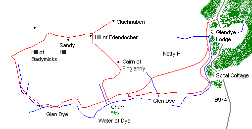
Clachnaben is a mountain to marvel at. It's by no means a big one, peaking out at 1900 feet, but it boasts a scenic quality that captivates everyone who lays eyes upon it. The hill is crowned by a dramatic granite tor, which can be seen for miles around. Up close it's even more impressive and while walkers potter up the popular footpath on the hill's eastern flank, a network of good estate tracks extending through lonely Glen Dye to the south offers an alternative route for walkers or mountain bikers, culminating in an airy high level section with panoramic views to Royal Deeside.
A wide solid path from the car park rises through trees and descends to the other side of the woodland. Turn left on track, which is fairly rutted and stony, and go south, crossing over a stream at the bottom to reach a junction. Carry straight on here, heading south. The track rises through an unlocked gate and climbs to reach a fork.
Take the left arm and the track runs level to junction a mile on. Go straight on here, curving right up Glen Dye, following the Water of Dye, down to the left. There's a long, gentle rise, then descent to a woodland and small reservoir beyond.
At the junction by the reservoir, turn right for a short uphill pull to a T-junction. Turn left and continue to the open bothy at Charr, half a mile on.
Turn right behind the cottage and a track climbs steeply, running parallel to the Brocky Burn. It swings right at the top, then descends before rising again, curving left on to Cairn of Finglenny. A short descent leads to the start of a one mile climb to the summit of Hill of Edendocher.
At the junction of tracks near the top of Hill of Edendocher, turn right and make the short detour over open ground to the summit of Clachnaben, about three quarters of a mile east. Retrace your steps to the junction, go right, and head west along the a peaty track which descends west over broad plateau, with some spectacular views north over Deeside. It rises over Sandy Hill and, at the next junction of tracks, go straight on for another descent before a gradual rise on to Hill of Badymicks. Continue on for half a mile from here to another junction.
At this point, turn left and the track descends steeply for a mile and a half, running parallel to the Burn of Badymicks. It flattens out lower down to reach junction at bottom. A stone stable over to the right affords shelter.
Turn left and head east along the base of the glen, following the Water of Dye. The track rises, curving right, then sharp left to descend to Charr, a mile on.
Carry straight on to the top junction above the reservoir. Don't turn right but carry straight on. The track rises gently above a small woodland of pine. It curves left to cross the Burn of Waterhead and climbs over the south shoulder of Netty Hill. Descend to the fork encountered earlier in the day and retrace the route from here to the start.
WALK FACTS
Distance 15 miles/24km
Map OS Landranger sheets 44 and 45.
Start/parking Public car park half a mile north of Bridge of Dye on B974 Fettercairn to Banchory road. GR: NO 649867.
Grading A long walk following forest path and estate tracks throughout. The high level section of the route is exposed with no shelter (other than peat hags). This route is suited to fit and fairly experienced hillwalkers. It can also be undertaken on mountain bikes, although there are three steep sections of ascent.