Deuchary Hill
By James Carron
Venture through the scenic countryside of Perthshire where views from the summit of Deuchary Hill are just one of the many high points.
In a landscape of little lochans, rolling moors and peaceful woodlands, Deuchary Hill rises undisturbed with a regal swoop, master of all it surveys. At just over 500 metres in height, it is by no means a tall peak compared to some of Scotland's more majestic mountains, but its hefty flanks are high enough to offer the walker an unbeatable viewpoint over the surrounding countryside.
A network of good tracks and paths make access easy and guarantee some of the best walking terrain in the country.
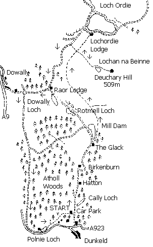
Leave the car park by its main entrance and head down the track for a short distance. Turn left and enter Atholl Estate at a prominent yellow sign and watch out occasional cars on this track. Stay with the main route heading north, passing by Cally Loch on the right. Although masked by trees you should be able to snatch a glimpse of this picturesque stretch of water.
The track continues north, passing houses at Hatton and Birkenburn until it reaches a high gate at The Glack, a remote pair of cottages. Go through the gate and the way curves up to reach the southern end of Mill Dam, a delightful wee lochan. Just before you reach the water, a path branches off to the right, entering trees skirting the edge of the water and this soon begins to climb over bracken-covered hillside.
Towards the top of the incline, you cross a lively little burn by an old stone bridge. Immediately after this, a path branches off to the right. Don't take this but carry straight on. The track climbs through a cleft between Deuchary Hill and a small outlying knoll. The way continues to ascend before finally flattening off. A little height is then lost and a good track skirts round the western flank of the hill with fine views over the surrounding countryside.
In due course, the route curves right and a track cuts across your path. Turn right here and follow it up to Lochan na Beinne. From there it's a fairly short pull over open hillside to the trig point marking the summit of Deuchary Hill. Enjoy the panoramic views then return to the lochan and follow the track back down to the junction. Carry straight on here, down the slope to a ladder stile over a deer fence at the bottom. On the other side you'll find a more substantial track. Turn left and follow this to Raor Lodge. When you reach the farm steading, turn right down the next track, passing through a gate and then a stretch of tall mixed woodland.
After half a mile of descent, the track reaches a gate and, beyond this, meets another track. Turn left and follow this as it rises steadily through farmland and above Rotmell Farm. The track continues to gain height gently above the main A9 road and River Tay down in the base of the wide Strathtay valley. The walk crosses open grazing land here and dogs should be on the lead.
At the end of the fields, the path enters a patch of leafy old deciduous trees.
Signboards mark the start of Atholl Forest. Carry straight on, ignoring a track on the left, and you will reach a high gate at the edge of a plantation of larch. The track runs level for a way before descending to reach a minor road. Turn left and follow the road east for about a third of a mile along a wide grassy verge until you reach Polnie Loch. A path on the left leads from here back to the car park.
WALK FACTS
Distance 12 miles/19km.
Maps OS Landranger 1:50,000 sheets 52 or 53.
Start/parking Caley car park, Dunkeld (grid ref NN 023437).
Grading Track and path through forestry and over open moorland suitable for fairly fit walkers of all ages.