A big bowl of punch
By James Carron
East of the main plateau, Glen Quoich has all the trademarks of the Cairngorms - lush woodlands of Scots Pine, grazing red deer, dramatic upland scenery and crisp, clear mountain streams.
Venture into Glen Quoich for a true taste of the unspoiled countryside that makes the Grampian mountains such a popular spot with walkers. Stretching north west from Braemar, the hidden valley curves into a peaceful wilderness where those who go quietly may see red deer nibbling green grass in the shadow of a gnarled old Scots Pine tree.
The peace and tranquility the forest affords is one of the main pleasures of this walk. The other is the lively river flowing coursing down the base of the glen.
Over its entire length, the route is never very far from the Quoich Water and the most spectacular section is saved for the end where the Punch Bowl always impresses.
The river squeezes through a narrow gash in the rock, whitewater thundering down the natural channel, crashing out into deep pools below. This walk can be tackled in all but the worst weather. For best results choose a warm, dry day and pause awhile to appreciate the spectacular surroundings as you go.
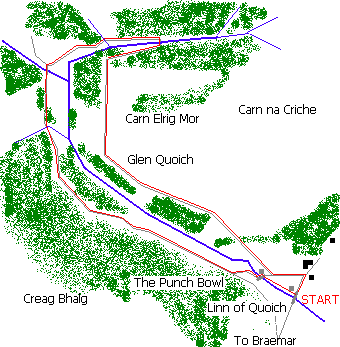
The car park sits just beyond the wooden road bridge spanning the Quoich Water. Set off east along the track to Allanaquoich farm. Just before you reach the whitewashed house, the track reaches a junction at the end of a small plantation. Turn left, curving back on yourself to reach a barrier gate.
Pass round this and follow the track along the back of the trees, small birds fluttering over the open moorland to the right. Five hundred yards on another junction is reached. Go right here and the track climbs open ground, leaving the trees on the left behind in a short distance.
Stay on the main track and a small burn is crossed at a point where a deep pool spans out across the track. Use the makeshift dam as stepping stones. The route climbs again, skirting behind a coniferous plantation to a track junction at the top edge. Turn left here and follow the back of the wood. You may spot red deer grazing in the trees.
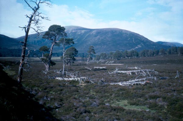
The track leaves the regimented plantation behind at another burn and the Scots Pine woodland to the left is now older and more sparce. There are a number of dead trees scattered across the moor, twisted white trunks rising from the heather. The way runs due north for a mile and then curves slowly east, a fine view to Beinn a Bhuird's solid rounded flank ahead.
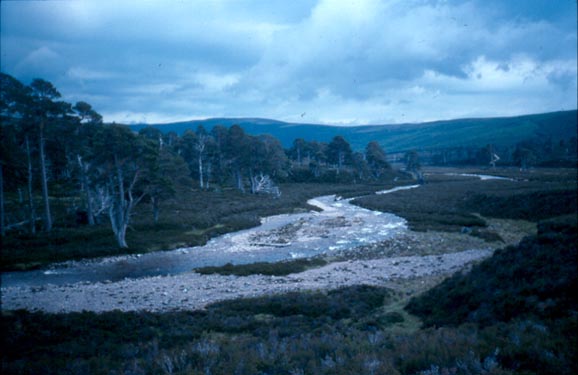
The track descends gently towards the Quoich Water on the left and meets the stream at a stony beach. The crossing is split in two by an island, a line of makeshift stepping stones covering the first section if the water is not too high. If it is, you have the choice of going upstream or taking socks off and wading over with bare feet in boots. The second stage is much easier. Once across, a track heads west through Scots Pine trees. There is a burn crossing part way along. Climb a few yards upstream and it is an easy hop.
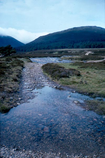
About a mile from the first crossing a junction of tracks is reached. Turn left and there is another river to negotiate. The track fords the water but walkers should head upstream a way where a mix of small grassy islands and narrow channels make a virtually dry foot crossing possible. Rejoin the track and walk south. The route curves gently left and although there are one or two undulations, on the whole it is level.
As the Quoich Water becomes more turbulent, the track reaches a wooden footbridge over the river down to the left. Don't cross this but stay on the track and continue to the end of the forest.
Fifty yards after the way leaves the trees, a path branches off to the left over open heather ground. It drops down to the riverside and crosses the water at a footbridge over The Punch Bowl. On the other side turn right before a boarded up cottage is reached and head down through the trees, a path leading back to the start, just beyond another abandoned house.
WALK FACTS
Distance 9 miles/14km.
Map OS Landranger 1:50,000 sheet 43.
Start/parking End of the minor public road at Linn of Quoich (grid ref NO 118913). Follow road signed Linn of Dee west from Braemar then east from Linn of Dee. Plenty of space for cars.
Grading Good tracks through scenic glen. Two river crossings where care is needed and avoid when rivers are in spate. Pack some midge repellent as they congregate at the car park. Suitable for adults and older children.