In the footsteps of a saint
By James Carron
St Cuthbert's Way is a 100km long distance route snaking through Border country from Melrose to Holy Island on the Northumberland coast. It links many historic sites associated with the former Bishop of Lindisfarne and there's a healthy collection of Roman remains along the way.
Hearty walkers can trek the entire route in as little as four days but the proximity of towns and villages with good public transport and fine hotels makes it possible to break it down into a series of less strenuous days out. As a taster, the first 15 miles from Melrose to Harestanes is an ideal introduction to the wanderings of a saint.
After starting his ministry in Melrose around 650AD, St Cuthbert moved to Lindisfarne where he became known for his powers of healing. He spent several years living in solitude on St Cuthbert's Isle then was appointed Bishop of Lindisfarne. He later returned to the island where he died and was buried. The coffin was opened some years later and his body was found to be perfectly preserved.
The tourist information centre next to Melrose Abbey is a good starting point for the walk. There are a couple of handy leaflets available. Before you set off, pop into the abbey for a taste of the area's religious background. It was built in 1136 by Cistercian monks and although badly damaged by English attacks during the 14th century part of the original church still stands.
Rebuilding continued through the 15th century and further work was undertaken in the 16th century but the Reformation was to take its toll. Part of the building remained in use up until the last century but most of the structure fell into ruin.
The abbey appeared in the news more recently when archaeologists unearthed a casket containing the heart of Scots king Robert the Bruce whose most famous moment came in 1314 when his army claimed victory over the English at Bannockburn.
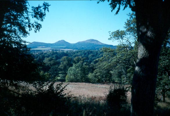
The way leaves Melrose by its charming if chaotic town square and climbs, via a long flight of wooden steps, on to the Eildon Hills. The three peaks offer fine views over the abbey and the rolling landscape of gently sloping hills and green fields radiating from its protective walls.
The way passes between two of the summits and remnants of an Iron Age fort once occupied by the Selgovae tribe. Evidence suggests there were as many as 300 houses in the main enclosure at the peak of settlement but the ancient people met their match in the Romans who demolished the fort in AD79 and built a signal station in its place.
The path descends to a lush green woodland where tall beech and pine trees throw a leafy canopy over the carpet of bracken and wildflowers. Continue down and the way skirts the bottom of the plantation to emerge at a farm track. Cross and it climbs through a small woodland to reach the peaceful village of Bowden.
This is a particularly pretty community where quaint cottages cluster along the tree-lined main street. Go over the main road by the tiny Post Office and a narrow road to the right leads down to a riverside path running east through a delightfully secluded valley. It reaches a farm steading and a quiet stretch of country road leads from there into Newton St Boswells.
Put the houses behind you and a real treat awaits - the River Tweed. It arrives on the scene as if by accident. The path losses itself in dense shrubbery after passing beneath the busy A68 and, when you least expect it, hurls you out on to one of the most spectacular viewpoints in the Scottish Borders. A deep blue river vista stretches away below, the Eildon Hills offering the dramatic backdrop for a scene well worth capturing on camera.
The path follows the river for the next stretch and you may be lucky enough to see heron fishing alongside the many ducks. An impressive suspension bridge offers access to Dryburgh Abbey. Here you'll find the graves of Sir Walter Scott, who died at Abbotsford in 1832, and first world war commander Earl Haig.
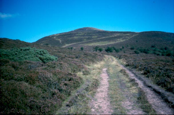
The way loops round to the bustling community of St Boswells and another peaceful riverside walk, part of it alongside a golf course, leads to Maxton and its unspoiled village kirk and graveyard. A narrow country lane runs from the church to Maxton, just a few houses scattered along the main road. Turn right and follow it to a road on the left signed to Longnewton. This crosses the trackbed of an old railway line and rises gently to the A68. Just before its junction with the busy highway, the way bears left into the trees, picking up the straight course of Dere Street, a Roman road built to link York with the Trimontium fort at Newstead, near Melrose.
Agricola's road into Scotland heads south through a strip of woodland before striking out across open fields. A short distance on Lilliard's Stone marks the site of the Battle of Ancrum Moor in 1545. The route of the road is well defined and as it heads south the grassy path now taking its place skirts through an impressive avenue of old oak trees.
Baron's Folly, a low stone tower built on the summit of Down Law, can be seen beyond the stone wall on the left and ahead the prominent Waterloo Monument rises into the sky from the top of Peniel Heugh above the River Teviot.
Beyond the avenue of oaks, the way crosses an open field to reach a minor road at a wooden stile. A gate on the other side leads into the trees and down to cross another country lane. Back in the woods, bear right beyond a wooden footbridge and a refreshing cup of tea awaits at the Harestanes Visitor Centre (open from April to October).
The way continues from Harestanes to Kirk Yetholm where it crosses the Pennine Way and the Anglo-Scottish border before heading east to Wooler then across Northumberland to the coast and the causeway on to Holy Island. Try it all, or just a bit. Whatever you decide, St Cuthbert would surely have given his blessing.
WALK FACTS
Distance 15 miles/24km.
Map OS Landranger 1:50,000 sheets 73 and 74.
Start Tourist information centre next to Melrose Abbey, Melrose (grid ref NT 547342).
Grading Low level route with path and track throughout.
Public transport The Lowland Scottish bus company operates routes alongside and close to the way. Timetable details from TIC, Melrose (Tel 01896822555).