
Round the Cape
By Colin Hogarth
A 33 mile expedition over remote country round Cape Wrath on the north west tip of the Scottish mainland.
After a peaceful night on the windswept campsite at Durness, we set off down the road to the Cape Wrath Hotel where we left the car before embarking on the short voyage over the Kyle of Durness. A small ferry plies the crossing daily in the summer and on demand during the winter. The journey takes a matter of minutes.
From the jetty to the lighthouse at Cape Wrath - 11 miles away - a minibus operates in the summer. However, as we were out to walk, it seemed only right we pass up this easy option and set off on foot while the other boat passengers were whisked away in relative comfort.
The track climbs steeply by a cluster of cottages and, as it gains height, spectacular views open out over the clear blue waters and white sand of the Kyle. The way crosses Ministry of Defence firing ranges, so check with the tourist office in Durness before you set off to ensure there is no army action planned.
Our route flattened out after the initial climb and soon we were making good progress over open moorland. The road dips to the River Daill and in no time at all we were standing above the shore of Loch Inshore. A small cottage sits by the track here and this is frequently used by soldiers as a makeshift bothy. The land surrounding this abandoned building is fairly flat, rising to only 300 metres. The track rises and falls over it's course to the lighthouse but there are one or two steep little hauls.
Further on the rusting hulk of a British Telecom van lay abandoned by the roadside - perhaps somewhere on this isolated plain there's an old lady still waiting for a man to come and mend her telephone? A little way on from here the track reaches a junction. The right hand option leads down to the MBA's coastal bothy at Kervaig. Our next port of call, however, was a small two-room bothy by the side of the main track. Again there was evidence of army use but the wee structure was in such a sorry state one would have to be pretty desperate to stop here for the night.
Four miles on we reached the lighthouse, the last outpost of civilisation on the north west tip of the Scottish mainland. The beacon is surrounded by a cluster of neatly painted cottages and workshops. The light is still in operation and can be seen some 40 miles out to sea.
On the hillside above the complex, are the ruins of an old wartime lookout post which is now home to the Cape's sheep population. With evening upon us we stopped briefly on the open moor here to consume a hasty supper of pilchards and pasta before heading south towards Sandwood Bay. With no obvious path to follow, we flitted between sheep tracks and stayed inland to avoid lengthy detours around the various coastal inlets.
Walking was hard going and the damp ground was seething with midges so rest stops were kept to the bare minimum to avoid a ferocious savaging from this tiny monsters. The ground undulates gently and there are several uphill sections, although none of these extend to a climb of any more than about 100 metres. The terrain is tussocky grass with few options to pitch camp.
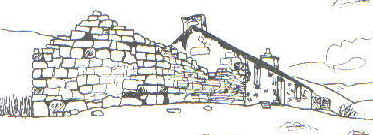
With darkness waiting in the wings, we hurried on and as the light began to fail we reached the door of Strathchailleach cottage. Spirits lifted by sight of a plume of smoke rising from the chimney into the late evening sky, we knocked eagerly. Tired and hungry we were looking forward to a hot meal and some convivial company. Unfortunately our inquiry met with a vocal tirade of abuse and, picturing the angry occupant reaching for his shotgun, we legged it. It's amazing how the taste of fear can transform stiff legs into the pins of an Olympic sprinter! (See separate Adventure feature for the full story on Strathchailleach and its renovation by the MBA)
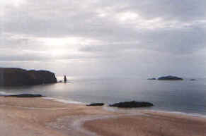
We slowed to walking pace with the cottage well behind us and meandered down to Sandwood Bay (pictured top) where we pitched up on the dunes between the wide sweep of beach and Sandwood Loch (pictured below).
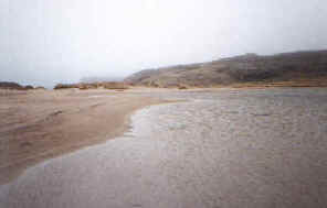
The following morning the sun blessed us with its heart-warming presence and we spent a pleasant few hours exploring the beach. Bounded by rolling dunes and crashing Atlantic breakers, the golden mile of sand extends south to Am Buachaillie, an impressive stack. Its name translates from Gaelic as The Herdsman. Above the bay is an old cottage reputed to be haunted by the soul of an old mariner.
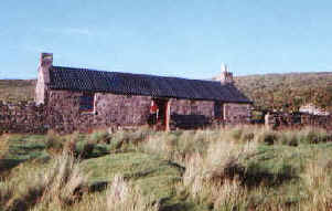
We spent a second night camping on the dunes before heading inland in a south-east direction along the south shore of Sandwood Loch. We followed the Lon Mor burn through Strath Shinary to the MBA bothy at Strathan (pictured above). This is a well maintained cottage with three rooms and an open fire. We fell victim to another lazy day and decided to over-night here. The day's progress was poor, but the weather was good and we decided to wander up to the summit of Creag Riabhach, the highest summit on the cape.
A cold night followed the balmy day and unfortunately there is very little firewood around Strathan and we hadn't had the foresight to cart some driftwood up from the bay. We tried heather (too smoky) and peat (too wet) and spent an uncomfortable night on the hard stone floor. On the bright side, we didn't have to endure the parties of outward bound executives that frequent this shelter, if the entries in the bothy book are anything to go by. According to one, an accountant was apparently dragged over the hills after breaking a leg. An accountant? Why on earth didn't they just break the other one and leave him on the moor?
The following day our trek took us along the north bank of the Lon Mor. A couple of miles from the bothy we were treated to some wonderful waterfalls before the terrain became increasingly bland. Again the ground was wet underfoot and there was no path to entrust our lives to. Fortunately the sky was clear and we were able to head up close to the Feith a'Chaoruinn burn, through the flat wide pass before descending down the course of the Grudie River to the southern tip of the Kyle of Durness. Keeping to the south side of the burn, we soon reached a house and then a bridge over the River Dionard which feeds the Kyle.
By now the sun had gone off sulking (as is often the way) and drizzling rain was making the final stage of our expedition north along the A838 road less than pleasant. We flagged down a passing mobile shop and, loaded down with sugary confectionary, some bananas and a big bottle of Coke, we completed the final four miles in fine style.
WALK FACTS - Distance: 33.5 miles/54km. Map: OS Landranger 9. Start/finish: Cape Wrath Hotel (grid ref 380663). Grading: A long hike over rough and exposed moorland. The route crosses MoD firing ranges used by the army and RAF. The tourist office in Durness holds details of when there will be military activity. Call 01862 810259 from Easter to October and 01862 810400 at other times of the year. Accommodation: SYHA, B&Bs and campsite in Durness. MBA open bothies at Kervaig, Strathchailleach and Strathan.