Beinn Dearg and friends
By Colin Hogarth
Do you want the good news, or the bad news, first? The good news? Well, here are four Munros packed tight together. And the bad news? A sea level start. But it isn't that bad as a well graded stalker's path provides access to this set of four peaks in Inverlael Forest, near Ullapool.
First up on this route is the most northerly outlier, Eididh nan Clach Geala (928 metres). This is followed by Meall nan Ceapraichean (977 metres), then Ben Dearg, the highest of the four at 1084 metres, and, to finish, Cona' Mheall (980 metres).
The starting point is Inverlael, at the southern end of Loch Broom. From the old fashioned red telephone box there, a track heads east past a house on the left to reach a gate and stile a few metres on. Cross over and continue up the track, through open grazing land, to the edge of a large forestry plantation. Go through the high kissing gate here and walk up the track, past a water treatment plant and then a forestry shed a little further on. Stay on the main track, ignoring a branch on the left and continue to a junction just over a kilometre on where, on the left, there is a small water supply installation. Continue straight on and the track soon curves left, dropping to cross the burn. On the other side, it bears gently right rising to the top edge of the forest where a metal gate leads out on to open moor.
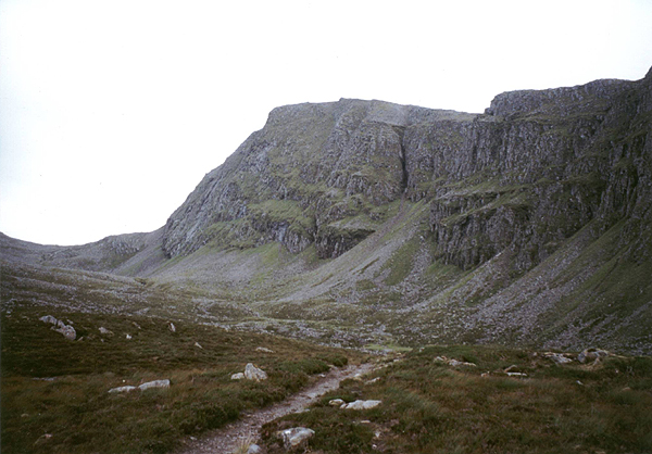
The next section of well-constructed path climbs steadily through the glen, the River Lael down to the right and the crags of Beinn Dearg in view up ahead. Soon the bulk of Meall na Ceapraichean, to the peak's left, emerges.
About three kilometres from the edge of the forest a junction, marked by a small cairn, is reached. To make the most northerly of the four Munros your first goal, go left here and the path rises through the heather, skirting left around the hillside and heading for Lochan a'Chnapaich. Soon the craggy mound that is Eididh nan Clach Geala comes into view and, with much height already gained, the summit looks tantalisingly close.
The path flattens off above the lochan and, rather than heading to the water's edge, it's easy enough to judge when to strike off up the shoulder on the left, bearing towards the rather stony summit when the time is right. Here fine views are afforded north-west to Loch Broom and south over the second Munro of the day - Meall na Ceapraichean.
A vague path heads south-east from the cairn, descending into the col below. The slope is grassy, dotted with small outcrops of rock so care is needed. The lowest point sits between two small pools of water where an obvious path runs east to west. Cross this and begin the ascent of Meall na Ceapraichean. We found no obvious path and instead picked a route up through the crags and rock strewn slopes, emerging on to the slightly lower of the two tops. From here, it's a short and fairly level plod to the high point.
The descent - there is a path - into the bealach between this mountain and its neighbour, Beinn Dearg is easy and well graded, dropping to a wide and fairly flat plain dotted with small lochans. Here you can decided whether to make Cona' Mheall or Beinn Dearg your next target. We opted for the latter, heading for the peak's steep north-east shoulder, a welcome gap through the fearsome crags on either side. The way follows a stone wall up - a handy navigational aid in the mist - and there's some very easy scrambling as you pick your way through and over a cascade of boulders. Over to the left, the sheer cliffs on the southern face of Cona' Mheall make a dramatic distraction.
Higher up the wall breaks right. Just before it does, a gap in the stone marks the beginning of a less distinct section of path that heads up over stony ground to the large summit cairn.
With Beinn Dearg in the bag, return to the wall and follow it down to its lowest point where a path leading to the final summit of the day is joined. On the OS map, the western face of Cona' Mheall looks like one big scree slope. However, the stone fans out around a reasonably grassy hillside and the well-graded ascent offers no particularly difficulty.
The return to Inverlael is straightforward, if lengthy. Return to the bealach the follow an obvious path down into Gleann na Sguaib. It sets off from the larger lochan in the col and descends quite steeply at first. Lower down it flattens out in the bowl below, skirting past a pond of perfectly clear water before following the burn down past a series of small waterfalls to join the stalker's path used earlier in the day. After a long day in the hills, there's every chance you will be rewarded with the sight of herds of red deer descending into the valley for the evening.
WALK FACTS
Distance 16miles/25km.
Map OS Landranger sheet 20.
Start Track end at phone box on A835 at Inverlael. GR: NH 183853.
Parking Space for cars on grassy verge of old road, next to phone box. Take care when parking as there are some exposed rocks in the grass.
Grading A long day out in fairly remote terrain. While there are good paths for sections of the route, in other places they are either vague or non-existent.