Walking the Minigaig
by Colin Hogarth
Scotland's newest long distance trail, the Great Glen Way, stretching 73 miles in length from Fort William to Inverness, officially opened this Spring, taking its place alongside the well established West Highland Way, Southern Upland Way and Speyside Way. All attract thousands of walkers a year. But if you're looking to wander far from the madding crowd, search out the country's forgotten network of old highways and byways.
Ancient drove roads and early trade routes, winding their way through remote and often wild country, await exploration by walkers and mountain-bikers looking to get off the beaten track. One such route is the old Minigaig road, linking Blair Atholl with Kingussie.
It was built towards the end of the 16th century and replaced an earlier route called Comyn's Road, constructed by David Comyn, Lord of Badenoch. Although there are few precise facts about when the latter was laid, the route was certainly in use during the 16th century. The story goes that Comyn created his link between Blair Atholl and Kingussie to transport a particularly fine ale from an inn near the Perthshire village to his Badenoch home.
After the Mingaig opened, it quickly became the main thoroughfare between Atholl and Badenoch, linking Blair Atholl with a castle at Ruthven, on the edge of Kingussie.
It was an important trade route, well used by travellers and cattle drovers but the traverse through the wild Forest of Atholl can have been no easy journey, particularly in winter.
The way follows the path of Comyn's Road for its first mile or so but, in the forest above Old Blair, branches right where the earlier road goes left up Glen Banvie. It rises steadily over open moor to join Glen Bruar and continues to the head of this lonely valley. From there, the Minigaig climbs steeply, setting a course across remote upland country to its highest point at 2745 feet above sea level (836 metres). From there, it descends via Glen Tromie to Ruthven.
During the winter months this high elevation would render the Minigaig impassable as drifting snow and blizzards engulfed the exposed track. Indeed, in 1745 a company of soldiers heading north to Ruthven Barracks was lost in adverse weather and there is little doubt that over the years unwary travellers perished on this high level passage.
In the 1720s, Scotland's most famous road builder, General George Wade, was despatched north to quell the Jacobite uprising. To enable his soldiers to move around the country relatively quickly, he set about improving the Highland's rather minimal communications infrastructure. In 1728 work began on a 102-mile long highway from Dunkeld to Inverness and it was this new route that would ultimately spell the end of the road for the Minigaig.
When Wade reached Blair Atholl, he continued west up the valley of the River Garry, rather than going north over the hills, and pushed on through the Drumochter Pass to reach Ruthven Barracks via a somewhat longer but, more importantly, lower and less exposed course.
The Minigaig continued to provide passage for many years after Wade's road opened and remained popular with drovers unwilling to pay the tolls at Drumochter. Years later Dumfries-born engineer Thomas Telford considered building a modern road over the Minigaig but he was dissuaded by the elevation and subsequent routes north ' including the present day A9 went with Wade. As a result, the old road has been inherited by walkers and mountain-bikers and forms the basis for an excellent wilderness trek.
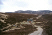
There is no better starting point for this epic two-day trek than in the turreted shadows of Blair Castle, seat of the Atholl dukedom. Dating from 1269, the imposing structure was seized by Bonnie Dundee, Graham of Claverhouse, who led the Jacobites to victory over Government troops at nearby Killiecrankie in 1689.
From the main road through Blair Atholl, I broke my legs in gently with a pleasant stroll up the tree-lined drive and on through the policies of the castle to the hamlet of Old Blair. A track strikes north from here, rising through Whim Plantation, the Banvie Burn gurgling down a steep gorge to the right of the way. Not only was I now on the Minigaig, but I was also following the course of the earlier Comyn's Road. That was soon to change, however, as I crossed the well preserved stone arch of the old Rumbling Bridge and the Minigaig became my new travelling companion for the 28 miles that lay ahead.
The track rises gently from here to the edge of the forest then strikes out over open moor, climbing to a prominent cairn. Where it crosses the Allt na Moine Baine a little further on, the remains of an old settlement that once sheltered in the valley of the stream are evident.
The track is solid and the walking easy here as the route has been retained and upgraded for use by estate vehicles. There are occasional remnants of the old road, in the form of milestones lurking in the heathery verge. The track rises between Carn Dearg Mor and Meall Dubh before dipping to an open bothy at Allt Scheicheachan. This former stable provides walkers with basic shelter but unfortunately isn't far enough into this route to justify an overnight stop. So after a bite of lunch and a cup of tea, I press on, crossing the bubbling brook from which the bothy takes its name. From here to Bruar Lodge, a little under two miles further north, the Minigaig is just a narrow path skirting through the heather. However, there is evidence of a properly engineered structure, albeit now lost in the undergrowth.
A working sheep farm nestling on the lower slopes of Beinn Dearg, Bruar Lodge was the last outpost of civilisation I would pass before Glen Tromie. From here on in I was on my own.
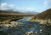
It was not until I snaked my way into the upper reaches of Glen Bruar, however, that I felt truly alone, lost from the world in a wild dream of rolling mountains and empty moorland, stretching uninterrupted to the horizon on all sides. As I crossed the last bridge in the valley, I stirred from my thoughts to find company in a golden eagle soaring high above.
I brewed a pot of tea on the bridge and watched the eagle ride the air currents, its beady eyes scanning the slopes for prey. There had been precious little in the way of wildlife thus far, save for the odd mountain hare still in winter garb despite the absence of any real snow cover a definite advantage for the hungry airborne hunter.
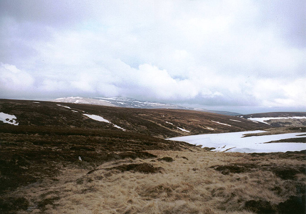
The track terminates abruptly at the bridge and a steep path climbs out of the glen, rising on to Uchd a'Chlarsair, an unremarkable wee lump. The peak itself may not be spectacular, but the sheer remoteness of its location is breathtaking. In fine weather, this is a tranquil spot, but it's not too difficult to imagine how dangerously exposed it could be if conditions suddenly deteriorate.
The Minigaig skirts the eastern side of the summit before dropping to cross the Caochan Lub. While the way is obvious enough on the high ground, as it dipped to the stream it became less easy to follow, partly because of some lingering banks of snow, and I ended up tramping through some pretty marshy ground, leaping across pools heavy with frog spawn and hoping lush swathes of moss would be firm enough to take the combined weight of me and my pack.
Fortunately, it wasn't too long before the path began to pull out of the glen, a well-graded ascent rising to the highest point of the Minigaig, below Leathad an Taobhain. From here, it was downhill all the way. With the clock ticking and the sun setting, it was time to find somewhere to bed down for the night.
Sadly the old road is in very poor condition as it descends the northern flank of Leathad an Taobhain. Large areas of boggy ground make it difficult to stay exactly on course and on more than one occasion I found myself tramping knee deep through wiry heather. But in a welcome gesture of appeasement, the glen did offer up a grazing herd of red deer, a wonderful sight to end the day on. The painfully timid creatures spotted the intruder in their landscape straight away and circled round behind me as I fought my way through the wild moor's ever tightening grip.
There are few places to camp on the slope, so, having lost the Minigaig completely, I opted to pitch my tent on the banks of the Allt Bhran lower down the glen and set about eating my supper as the sun set. Red sky bode well for the next day.
April is an unpredictably month when it comes to the elements. Having packed plenty of warm clothing expecting low temperatures, day two dawned hot and sunny real T-shirt and shorts weather. Thankfully Id come prepared for such an eventuality.
The first hour of the day was spent trying to find the route of the Minigaig again. In the end I opted to simply follow the Allt Bhran downstream, finally finding a path leading to a weir over the burn. From here, a good track took me into Glen Tromie where my wilderness experience ended abruptly as I joined a tarmac road at a recently constructed estate house.
Ahead of me lay a blistering eight miles of hard walking along a surfaced road, an experience which sadly does little for the soul. On a more positive note, however, there is evidence of significant recent native tree-planting here so in 20 or 30 years time Glen Tromie should be a marvelously leafy environment.
With aching feet, I finally emerged at Ruthven Barracks, a garrison for Government troops built following the Jacobite Rebellion of 1715. Twenty-six years later a fleeing Bonnie Prince Charlie ordered its destruction and it was gutted by fire.
Below the magnificent ruin runs the busy A9. Had Telford who built over 1000 miles of road and some 1200 bridges during his career pressed ahead with his plans perhaps the transport network in this part of the country would have been very different. But then a Minigaig heavy with juggernauts would have denied walkers a truly memorable experience.