Gleann Auchreoch
By James Carron
Enjoy a circular walk through old and new forestry on the lower slopes of Beinn Dubhchraig, with some spectacular waterfalls thrown in for good measure.
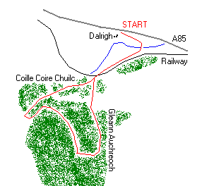
Set off from the car parking area at Dalrigh down a surfaced road leading to a substantial bridge spanning the River Fillan. Pass through a wooden gate and cross the bridge then follow a good track as it curves up to the right. The way rises a little before flattening out and running alongside the Crianlarich to Oban railway.
Just over a kilometre from the bridge, the track crosses the line by a bridge and there's a gate to go through here. Stay with the track and follow it towards a sparse area of old woodland. The way climbs through trees, with the Allt Gleann Auchreoch down to the right, and continues to rise over open hillside before curving up into Gleann Auchreoch where the track enters commercial forestry at a metal gate.
Follow the well made up track for just over a kilometre to a junction where another track drops to the right. Take this. The way descends to a wooden footbridge over the Allt Gleann Auchreoch then climbs through a gate. As it ascends from the bridge, the track turns north before rising gently through trees, contouring round the lower slopes of Beinn Dubhchraig, a Munro.
After a final steep climb, the track ends. From here, continue straight ahead over a path of open heather hillside to the edge of the Allt Coire Dubhchraig. There is no bridge but an easy crossing can be made just above a junction of burns, taking each of the two tributaries in turn. Once over, pick up an obvious and fairly eroded path, go right and start descending. This section can be very wet underfoot, depending on the weather. As you go down look out for waterfalls to the right.
At the edge of the next patch of forestry, cross a stile and continue on a good path through Scots Pine trees. Take care because the exposed roots can be slippery when wet.
The route drops to another stile, then threads a course through the trees to the bottom of the woodland. A bridge crosses the Allt Coire Dubhchraig and a path leads through heather and grass back to the bridge over the railway. From here retrace your steps to the start.
WALK FACTS
Distance 7 miles/11km.
Map OS Landranger sheet 50.
Start/parking Dalrigh on A85 two kilometres south-east of Tyndrum. GR: NN 344292. There is plenty of space for parking here.
Grading A moderate walk with track and path throughout, although terrain can be muddy in places. Suitable for fairly fit walkers of all ages.