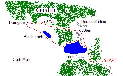
The Cleish Hills
By James Carron
Tucked away in the southern most recess of Perthshire there lurks a real treat for walkers ' the Cleish Hills. Overshadowed by the neighbouring Lomonds, this range of low craggy peaks dotted with small lochans and carpeted in forestry offers an excellent half day walk.
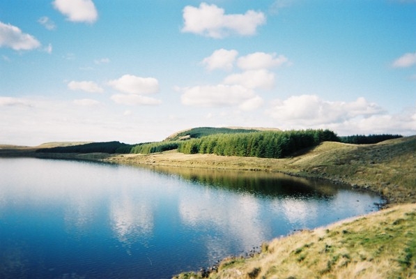
There is a small Forestry Commission car park just off the road at the start. Leave this at the barrier gate and head west along a good forest road. Hemmed in by trees the track reaches a junction around 500 metres on. Bear right here, remaining on the main track which descends gently to reach a small anglers' car park at the eastern end of Loch Glow. Here there are fine views over the water to the various summits of the Cleish Hills.
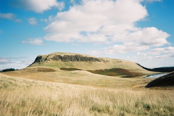
Cross a stile by a gate ahead and follow a track skirting below the low dam at the head of the loch. Go over a wooden footbridge spanning the concrete outflow channel and turn left, following a fence up to a metal ladder stile. Cross and, a few metres on, leave the main lochside path and head north-west, following a fairly vague path through the grass, up the shoulder of the first 336 metre high top. The ascent is pretty strenuous but good views open out over Loch Leven and the Lomond Hills to the east as height is gained and you reach the top of the first knoll. From here, descend into a narrow, steep sided little ravine and climb on to the top of the hill.
Descend back into the col and, in the base, bear right and pick up a path in the grass leading to the edge of a forestry plantation. Here an obvious path leads up through a break in the trees. There is no gate into the wood but there is a gap in the fence.
The peaceful sheltered path rises through the densely packed conifers, emerging on to a forest road midway up. Cross this and stay with the path as it disappears back into the trees.
Light is soon visible at the end of the tunnel. The path exits the plantation at the top and curves right, climbing gently through grassy moor to reach the summit trig-point and cairn. Pause awhile here and enjoy views east over Loch Leven and the Lomond Hills and north to the Ochils.
Leave the summit and descend west, a narrow and fairly steep path picking its way down through craggy outcrops. At the bottom, cross moorland to reach the edge of the woodland at GR: 073964. Follow the edge of the plantation west to its top corner and then head over open hillside to the top of Dumglow.
From here, descend south to the boundary wall. Cross it, pick up a path and go left, following the wall down to Black Loch. Stay with the boundary line as it crosses open ground to reach the western tip of Loch Glow. Follow a path on the northern shore round to the dam and retrace steps from here to the start.
WALK FACTS
Distance5 miles/8km.
Map OS Landranger sheet 58.
Start/parking Small Forestry Commission Loch Glow car park midway along single track road between Cleish Mill (on B9097, two miles west of M90 Junction 5) and Greenknowes. GR: NT 099955.
Grading Track and path throughout, although some sections can be wet underfoot. Be prepared for some short but fairly strenuous sections of ascent. Sheep grazing on open land means dogs will need to be on the lead.