Where giants slumber
By Colin Hogarth
To southbound travellers on the M90 motorway the Lomond Hills bear an uncanny resemblance to a sleeping giant. Venture on to this slumbering form and you will find a landscape full of folklore and history. Below the summit of West Lomond is the deep ravine of Glen Vale where exiled ministers in the 17th century held secret meetings. As a result it became known as Covenanter's Glen. Above this is a craggy outcrop called the Devil's Burdens and legend has it that local witch, Carlin Maggie, was turned to stone here after she dared to challenge Satan on nearby Bishop Hill. Aside from these local tales, there is evidence of ancient forts near Craigmead and on the top of West Lomond, and the Romans did battle in the area.
At Craigmead, follow the sign for West Lomond, the path starting at a kissing gate to the rear of the car park. The route takes you through a clump of trees to a stile leading out onto the open grassy hillside. Bear left and climb up the gentle slope to meet a track hemmed in by two stone dykes.
Follow the track as it cuts a course through the heather. It rises gently and all the time the pronounced lump of West Lomond is in view ahead. Excellent vistas open up to the north over the agricultural lands of the Howe of Fife and the River Tay. On a clear day the mountains of Perthshire are visible in the distance. The two towns down to your right are Strathmiglo and, a little further east, Auchtermuchty where the ITV drama Doctor Finlay was filmed in recent years.
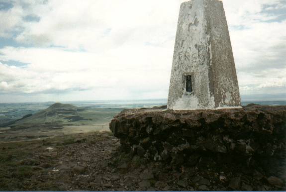
As you reach the base of West Lomond, take the path to the right. This skirts round the hill and is recommended as the direct route to the top was badly eroded and efforts are being made to combat this problem. The wide grassy way soon offers views east over Loch Leven, a national nature reserve. Mary Queen of Scots was imprisoned on the more northerly of the two islands as she awaited her eventual execution. The summit is now just a short, steep climb away. The top of West Lomond, at 1713 ft, is marked by a large cairn and, next to it, a trig point. To the east you can see her sister hill, East Lomond.
To continue the walk, pick up a small path on the south side of the summit. This descends steeply to a stone wall. Turn left and follow the wall over open moorland to a wooden stile. The path is narrow and a little indistinct in places. Cross the stile and descend to another one below. Don't cross this one, but follow the wall south to a third stile. Go over this one and walk east through a field of rough grass dotted with patches of cotton to a gate and, next to it, a bridge. These are located at the top end of a forestry plantation.
Once across the bridge, a gravel track skirts round the back of the trees to reach Harperleas Reservoir, part of Fife's public water supply.
Continue along the southern edge of the reservoir until you reach the dam and walk north across this. On the other side a track climbs behind the ruin of an old farmhouse. Follow this east as it runs around the hillside above Ballo Reservoir and finally emerges on to the public road a little way south of Craigmead. Turn left and follow the road back to the car park.
WALK FACTS
Distance 6 miles/10km.
Map OS Landranger 1:50,000 sheet 58.
Start/parking Craigmead car park, two miles from the village of Falkland (grid ref NO 227062).
Grading A fairly easy walk through undulated countryside with short but steep ascent and descent of West Lomond summit. Dogs are not allowed within the perimeter of Harperleas Reservoir and there is sheep grazing on the moor.