Crail to St Monans
By Colin Hogarth
The East Neuk village of Crail is perhaps best known for its picturesque harbour, a spot that draws artists from around the country. It is also the starting point for this walk south along the Fife coast. The route follows part of the fledgling Fife Coastal Path and is a great introduction to this long distance walk that will, once complete, link the Forth and Tay road bridges.
From the harbour, head up to the centre of the village, turn left and follow the main street south to West Braes. Turn left into this narrow lane and walk out towards the coast. It curves right and the left along Osborne Place to meet the coastal path on the edge of the Crail. A wooden sign marks the start of this next stretch of coastal walk and a wide gravel path strikes out, dropping to a grassy bank above the foreshore.
The path is good but becomes dotted with rocks as you approach a boarded-up cottage at The Pans. The way crosses a wall and continues to Caipie Caves, said to have been a dwelling as far back as 2000BC.
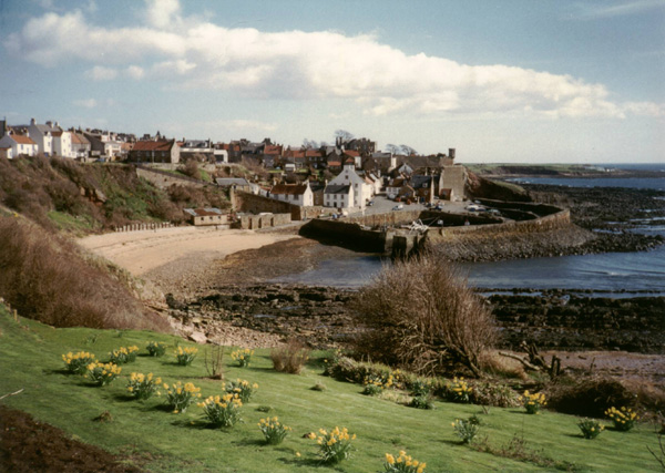
The path goes on past a farm to reach Cellardyke. The approach is through Kilrenny Mills Caravan Park. Follow the road straight along The Cooperage, a narrow street of traditional East Neuk fishing cottages. Continue on Shore Street and then James Street and bear left when you reach the main road to reach the town centre and harbour.
A colourful array of fishing boats occupy this safe haven and the Scottish Fisheries Museum, which opened in 1969, is well worth a visit. Exhibits are displayed within old cottages and boat-building sheds clustered around a courtyard. Wander along the harbourside and enjoy fish and chips or an ice-cream on one of the waterfront benches as you watch fishermen at work.
At the far end, before the main road curves right, drop down on to the beach and, a few yards further on, stepping stones take you across the Dreel Burn in the shadow of the town's kirk. A short flight of steps leads up to the main road. Head south out of town, passing the Dreel Tavern, and take the next road on the left. Turn right in front of the primary school and Shore Road leads out to the local golf club. Beyond this the coastal path skirts a sandy beach with the next port of call, Pittenweem, looming into view.
Steps rise to the edge of the town and a grassy path runs between houses and the cliff top, emerging on to Abbey Wall Road. It curves left, descending to the busy fishing harbour. Mid Shore and East Shore take you on through a car park and a tarmac path meanders along the front of a row of seafront cottages above the beach. Walk on along the sand and the coastal path skirts by an outdoor swimming pool. Continue to St Philip's windmill, an 18th century structure on the edge of St Monans.
The gravel path borders a park until it reaches a car park. Follow the road straight ahead to St Monans harbour.
WALK FACTS
Distance 7.5 miles/12km
Map OS Landranger 1:50,000 sheet 59.
Start/parking Crail harbour. GR: NO 612073. Plenty of on-street parking in Crail.
Grading Well graded and well signed coastal path, eroded and overgrown in places but easy to follow. This walk is a linear one and regular Fife Scottish bus services link St Monans with Crail for the return journey.