Camasunary Bay from Elgol
By Colin Hogarth
A coastal path leads from the scattered community of Elgol into the shadow of the jagged Cuillin peaks. It skirts the shores of rippling blue waters of Loch Scavaig, offering some spectacular views of the famous mountain range. You can also spot the island of Soay, Rhum and Canna on a clear day. You'll need a head for heights for some sections where the path skirts above steep drops into the sea.
The route begins in the public car park in Elgol, sited just above the village pier. As the car park is located part way down a steep road leading to the harbour the first stretch requires a hard pull back up. But just as you start to run out of puff, a signpost for Garsbheinn points down a track to the left. Follow this as the way passes couple of cottages. When it enters a gate into the garden of a house at the end, branch off along a small path on the right, signed to Loch Coruisk. This leads out over grazing land high above the swirling sea. There are excellent views over Loch Scavaig to the Cuillin ahead and west across the sea to the island of Soay.
The path drops to cross a burn then continues along the coast. The slope is steep in places with quite a drop below, but it flattens out as it descends to the beach at the end of Glen Scaladal. Cross the burn here and then the path climbs up on the far side of the stony shore. Make sure that the path you takes runs above the trees as there is a sheep track below which goes nowhere.
Back up on the cliffs, proceed with caution and, if you have young children or a dog with you, make sure to keep them in check. Be warned, the slope below becomes increasingly steep with a dangerously long drop. If you are sensible, it is perfectly safe, but may not be the most pleasant of walks for those who suffer from vertigo.
The path finally emerges into a grassy field where it crosses a stile and runs round to the beach at Camasunary.
Walk along the beach which is overshadowed by the craggy bulk of Bla Bheinn up behind it. At the west end there's an open bothy with magnificent views down Loch Scavaig. This is a great place to stop for lunch.
Back at the east end of the beach, a track crosses a bridge then rises up over the hillside. The climb is hard going and a shortcut half-way up takes out one of the loops.
The current track in to Camasunary was built in 1968 by the army. While the ascent section is fairly rough underfoot, particularly at the top, the rest of the route to Kilmarie is fairly well maintained and the walking is easy. It's downhill most of the way to the hamlet of cottages where the track joins the A881 at a small car park.
Turn right and follow the road south back to Elgol. It is a fairly quiet single track route, but keep an eye out for traffic all the same. The route climbs past a small cemetery and skirts round the western flank of Ben Meabost. Stay on the main road when it passes by a turn-off on the left leading down to crofts at Drinan. The road curves right and you soon reach the first in a series of scattered cottages on the edge of Elgol. The road leads down past two churches and a small shop where refreshment can be found before descending towards the car park.
WALK FACTS
Distance 9 miles/14.4km. ;
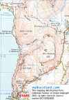
Map OS Landranger 1:50,000 sheet 32. ;
Start/parking Elgol car park (grid ref NG 519137). ;
Grading Low level coastal walk, returning via moorland track and quiet
country road. Take care on the coastal path as some sections skirt alongside steep drops. This is not a route for those who suffer from vertigo - a head for heights is needed in places.