Raasay's Iron Brew
By Colin Hogarth
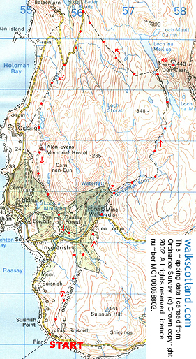
The beautiful island of Raasay lies off the east coast of Skye. This circuit round the southern end offers isolated moor and upland lochs plus some dramatic coastal scenery. You can also explore some relics of the island's iron mining history.
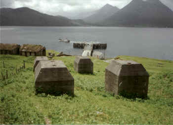
The tiny Caledonian MacBrayne ferry MV Raasay provides a regular crossing from Sconser on Skye to the island. Set off from Raasay ferry pier and head up the trackbed of a disused railway line. Unlike more traditional railways, this one was cable-hauled due to the fairly steep grade of the incline. It rises to the left of old buildings associated with the mining, passing a huge concrete hopper and kilns. It soon flattens out and continues more gently to the ruin of an old motorhouse up on the moor.
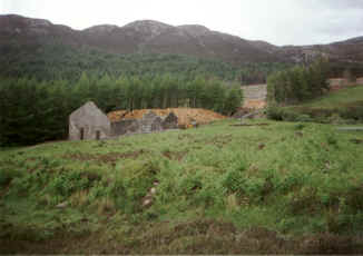
Cross a post and wire fence here and walk through a break in the trees. A narrow path is easily found and this takes you up to an old viaduct. The tall concrete piers are all that remain nowadays and you must head down the steep bank into the narrow little glen below. Climb out the opposite side and follow the course of the track until you emerge from the trees and reach more ruined mine buildings.
Tucked away in the foliage just beyond these concrete structures is a mine entrance which gave access to a grid formation of underground passageways from which the ore was extracted.
This is one of Raasay's two iron mines. They were developed during the first years of this century and were linked by railways to the processing plant and loading pier at Suisnish, where our walk began. Wagons were hauled on cables driven by diesel-electric motors. The mines operated through the first world war when German prisoners provided labour. Production ceased in the Spring of 1919.
From the tunnel opening, continue up alongside a fence separating the open moor from Raasay Forest, a commercial plantation. At the top end of this, the path crosses the Inverarish Burn and follows close by the stream through heather. The route is obvious for much of the way but it becomes a little less distinct as you near Loch na Mna. However, a couple of cairns provide handy guidance. Carry on to the loch, then follow the valley to the head of Loch na Meilich, the source of Raasay's drinking water. It is worth making a short detour to climb on to the summit of Dun Caan, a fascinating little flat-topped hill shaped like a volcano. This is a prominent landmark, visible from the Scottish mainland.
Enjoy excellent views, then return to Loch na Meilich. Climb up a small stony ridge and begin the long descent, a path falling to the single track road which you should follow south.
After about a mile, the road turns sharp right at a junction. Leave it here and go south on the roadway past Raasay's tiny SYHA hostel. The way descends through Raasay Forest towards the cluster of cottages at Inverarish.
Just before you reach the village, the route meets up with the main road. Turn left but rather than going down into Inverarish at the next junction just a few yards on, follow the road east until you come to some concrete viaduct piers. By a bridge abutment on the right hand side of the road, there is a path which guides you through the trees back out on to the open hillside. A short way on is the motorhouse encountered earlier in the day and from here you just need to retrace your steps to the ferry pier.
WALK FACTS
Distance 12 miles/19km. ;
Map OS Landranger 1:50,000 sheet 32. ;
Start Raasay ferry pier at Suisnish (grid ref NG 555342). ;
Parking At the ferry pier on Skye.
Grading Open moorland with path and track throughout, some of it a bit indistinct. Take great care around the old mine buildings which are less than solid and don't venture into the old mine. ;
Ferry info The Raasay ferry makes around seven crossings a day Monday to Saturday with no Sunday sailings.