Coast to coast across Skye
By James Carron
Strath Mor, a four mile long glen between Loch Ainort and Loch Slapin, is the narrowest strip of land between the north and south coast of the Isle of Skye. The coast-to-coast link makes up part of an excellent circuit starting out from the tiny community of Luib where traditional crofting cottages have been restored. The Luib Folk Museum is well worth a visit on your return.
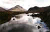
Good paths skirt through scenic glens with rocky, scree-covered peaks looming overhead. Along the way small blue lochans nestle in their shadow. The famous Black Cuillin peaks are just a stone's throw away while Bla Bheinn, a magnificently craggy mountain isolated from the main ridge, rises up from Loch Slapin.
Sheep and cattle graze these glens and there is plenty of wildlife to look for. The Stonechat, with its characteristic call like two stones being knocked together, is common. On the burns there may be dipper and grey wagtail, while kestrel, buzzard and eagle soar the high crags. Otters are not uncommon on the sea lochs while red deer may be spotted on the uplands.
Spring and summer are fine times to do this walk when clear sunny weather offers the best views. With snow on surrounding peaks, the winter months provide a spectacular contrast.
As the burn running through Luib to Loch Ainort passes beneaththe minor road, a grassy track strikes off to the left. There's a metal gate and on one of the gateposts a small red arrow. Climb over the gate and follow the way as it starts to rise up behind the tiny community. A short way on pass through another gate and then the track climbs round Am Meall, following a post and wire fence on the left. As you progress, views open out south down Strath Mor, the glen through which the walk returns. The track reaches a small stone milestone at its highest point.
From the milestone, the track drops down to skirt round behind Dunan where the ruin of a church sits just below the way. At the church, there are views out over Loch na Cairidh and the narrow channel between the Skye mainland and the island of Scalpay just off-shore. Continue down the track and above Strollamus the track passes through a gate and drops to an old stone bridge over the Allt Strollamus.
Just before the track goes over the bridge, an obvious path branches off to the right, crossing a small burn before rising up through the heather. Take this and begin the gently climb through An Slugan. The path sticks to the right hand bank of the river all the way up. Continue up to the point where the Allt Strollamus and Allt na Teangaidh converge.
Above the junction of burns, a collapsed river bank interrupts the route but stay on the right bank and the path is soon picked up again. Follow it up to the col where a lonely metal gate sits on the moor. At the gate, the way flattens out but is wet underfoot. It then begins the descent down Strath Beag to Torrin, cutting a course over the hillside, this time to the left of the burn. Views open out over Torrin and Loch Slapin. As the path approaches Torrin it crosses a burn and on the other side there is a fenced area. When you reach this point, walk to the right of the fence and then diagonally over open grazing land to meet the road between a new house to the left and on the right a white house, a former church marked by a cross on the OS map.
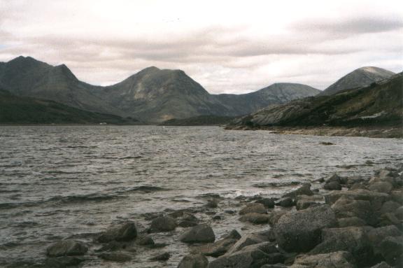
Emerge on to the road near to the Torrin sign. Turn right and follow the A881 down on to the shores of Loch Slapin, passing by an outdoor centre on your left. Across the water is the craggy bulk of 928 metre high Bla bheinn. It is the only Munro in Skye which is not part of the famous Black Cuilin ridge. The ascent is equally rewarding, however, as the climb offers some stomach-twisting scrambling and there are spectacular panoramas from the top. Marvel at the mountain as you continue north along the road, past a small marble quarry, to a bridge over the river at the head of the sea loch.
Just before the bridge, a track strikes off to the right. Take this and follow it up towards the first of the two lochans hidden in the glen. Loch na Sguabaidh is a fine spot for trout fishing with permits available from the post office in Torrin. The path follows the east shore for a way before heading out over the moorland where grazing cattle are often to be found. Ahead the sloping ridge of Glas Bheinn Mhor dominates the view and to the left is the craggy face of Belig. Continue on to the south end of Lochain Stratha Mhoir.
At the south end of the second stretch of water, the path crosses the glen to run along the west side of the water to the far end. From the end of the lochan, the path curves left round the hillside towards Luib. This next stretch is fairly boggy and remains so until the path reaches a post and wire fence. From the fence, the way descends to Luib and emerges on to the roadway just beyond a ruined cottage on the left.
WALK FACTS
Distance 11 miles/17km. ;
Map OS Landranger 1:50,000 sheet 32. ;
Start Luib, six miles north of Broadford on A850 (grid ref NG 565278). ;
Parking By the BT phonebox in Luib or on roadside nearby. ;
Grading Track and path through remote glens with some easy ascent, suitable for fit walkers and older children.
Strath Mor can be pretty damp and marshy underfoot in places, particularly around Lochain Stratha Mhoir.