Skye walking
By James Carron
Experience the remote wilderness of Skye with a hike across the moors to a long-abandoned coastal community. Few places feel more remote than a deserted village, where empty cottages lost in the landscape adopt an eerie presence. The crofting communities of Boreraig and Suisnish are two such hamlets. Occupied for centuries, they were victims of the brutal Highland Clearances during the mid-19th century. Families were moved from the land to make way for sheep. Some found new crofts on the island, but many emigrated to Australia.
Animals still graze the area, but the only signs of human habitation now are the well preserved cottages above the rocky foreshore. This route skirts through the ruins and offers a real taste of remoteness.
From the car park, walk north from the church on the main road to a track on the right. Follow this up to a large brick wall and shelter and bear left around the structure. Pick up a grassy path climbing through the bracken to a track running level across the hillside.
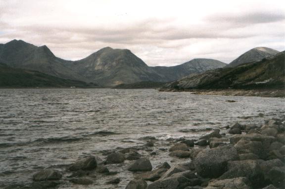
Turn right and take the track (the course of a former narrow gauge railway) to the remains of a marble quarry. Skirt left and climb a grassy incline to more quarry workings. Beyond these the track rises over open moorland to reach its high point at a rusty fence west of Loch Lonachan. The path runs above the Allt na Pairte before descending to the coast to reach the shoreline of Loch Eishort at Boreraig. It swings right through the bracken and meanders by the ruined stone cottages and enclosures. The path then skirts the shore from Boreraig, passing below high cliffs where waterfalls fan out over the steep slabs of dark rock.
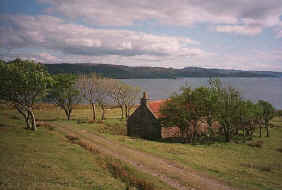
Below Carn Dearg, the path climbs from the beach to Suisnish, a handful of abandoned buildings standing above Rubha Suisnish point. Follow the fence along above a large green barn, curving left to meet a track next to an old red roofed cottage.
The track heads north along Loch Slapin, with views across the water to Bla bheinn and the Cuillin. It passes a couple of deserted buildings and crosses several burns before turning inland to the bay at Camus Malag. Join the single track A881 road east of Torrin village and follow this past Loch Cill Chriosd to return to the start.
WALK FACTS
Distance 10 miles/16km. ;
Map OS Landranger 1:50,000 sheet 32. ;
Start/parking Ruined church and graveyard at Cill Chriosd on the A881 two miles south of Broadford (grid ref NG 617207). ;
Grading A long but fairly straight forward walk with path and track throughout. Some sections can be wet and muddy underfoot.