Torridon trek
By Colin Hogarth
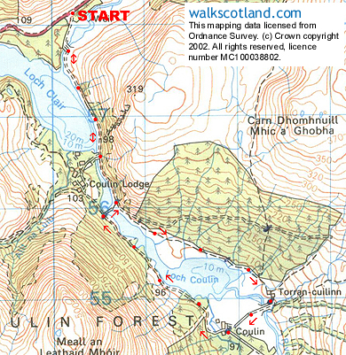
The magnificent scenery of the Torridon mountains forms an impressive backdrop to this easy and picturesque track walk which skirts along the shores of Loch Clair and around neighbouring Loch Coulin.
The outward section of this walk follows the Coulin Pass, an historic right of way leading to Achnashallach. It was originally used by cattle drovers but is now popular with walkers keen to discover the many and varied delights of Torridon. Beinn Eighe is the most easterly of the Torridonian mountains and its long quartzite scree-covered flanks are clearly seen from our route.
From the A896 set off down the metalled road leading into the Coulin Estate, heading towards Loch Clair, Cross a bridge and then follow the road as its runs alongside the loch. Stop every now and then to take in the impressive sight of Beinn Eighe behind you.
At the end of Loch Clair, you arrive at a wooden bridge. Don't cross this but keep walking straight on, passing through a gate and below a waterfall on the left, and continue alongside a beautiful stretch of water. Depending on the time of year, the track is coloured by purple heather and rhododendron, and, up to the left, Scots Pine hug the craggy slope.
As you approach a second bridge, stay with the track, passing by the bridge. After a short distance, a path branches off to the right. Take this narrow, stony way which is likely to be wet and muddy in places. It ascends gently away, passing through a gate without a fence and then descends towards Loch Coulin again.
Just before you reach the white cottage at Torran-cuilinn, the path is diverted round a small stand of scrawny trees and it then goes over a grass field to reach a bridge. Cross this and take the track right heading towards a large white farmhouse. Follow the track round the left side of the building and continue north-west towards Loch Coulin. The route follows the waterside north west, to reach the bridge passed earlier. Cross and a short path leads back to the track. Retrace your steps to the start from here.
WALK FACTS
Distance 5 miles/8km. ;
Map OS Landranger sheet 25. ;
Start/parking Small unofficial car park on the A896, three miles west of Kinlochewe (grid ref NH 003582). ;
Grading An easy track and path walk suitable for all abilities at all times of the year.