Navigating the Ness
By James Carron
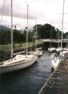
One of Scotland's engineering marvels, the 60 mile long Caledonian Canal was created last century by Thomas Telford to provide boats with safe passage from one side of the country to the other. It cuts a course through the natural fault line of the Great Glen from Inverness to Fort William and incorporates four lochs in its route, including Loch Ness, home of the famous monster, Nessie. There are 28 locks in total, lifting vessels from sea level at each end to over 100 feet above sea level at the highest point. Two can be seen in action at Dochgarroch, the start of this walk, where yachts are frequently found negotiating the step as they cruise the peaceful waters.
Originally built to ease the flow of goods, pleasure craft are now the main users of the canal and, as you follow its course, you'll see a colourful array of boats tied up on its water-side pontoons.
From the small car park by the canal, cross the locks at Dochgarroch and head north on a wide grassy towpath running alongside the canal. The route follows a narrow island separating the canal on your left from the River Ness on the right. At this point the river is concealed by a dense bank of shrubs and woodland and it's easy to forget you are effectively walking a tightrope between the two. On the opposite side, yachts line the canal, many with names clearly inspired by the great outdoors - 'Ben Nevis' and 'Glen Affric' among them.
The path runs below two pylon lines and continues north, by a boarded up cottage on the opposite shore. There are occasional paths through the trees on the right to the riverside. Beyond another line of pylons, the ground opens out and the river becomes clearly visible. You will often find fishermen here, flycasting into the wide, shallow flow. Continue on the towpath, ignoring a set of steps down to the right.
In a short distance the most northerly point of the walk is reached, a swing bridge taking the A82 over the canal. Cross the bridge and, on the far side, turn left and head south, this time on the other side of the canal. Pass by a small car park and the Jacobite Cruises booking office and continue between the canal and a golf course on the right. The way passes a shed belonging to the Inverness Rowing Club a few yards on.
South of the shed, the path is sandwiched between the canal and a steep bank on the right. At the end of this a black barrier gate is reached and, beyond this, a cluster of houses. The path leaves the canal here and follows a track on the right up between a set of hedges. Head up to the next junction half a kilometre on and bear left here, walking out along a track bordering woodland. Carry straight on, passing a path on the right and then a track on the left leading down to the boarded up cottage at Dunaincroy. At the end of the track, a path curves down, skirting woodland and gorse bushes, to rejoin the towpath coming in from the left at a stile. Go straight on and the way follows the canal past pontoons and a boat charter business shed to emerge at the Dochgarroch locks.
WALK FACTS
Distance 7 miles/12kms. ;
Map OS Landranger 1:50,000 sheet 26. ;
Start Locks at Dochgarroch (grid ref NH 618405). ;
Parking Small car park by the canal. To reach it, leave the A82 at the Dochgarroch shop and follow a narrow road signed for campsite. ;
Grading An easy walk on flat canal towpath and woodland/farm tracks. British Waterways request no swimming in canal and, if you're taking a dog, don't let it foul the towpath.