Pitlochry to Killiecrankie
By Colin Hogarth
If you're looking for a walk that offers a real contrast between rough upland terrain and more civilised lowland slopes, this route from Pitlochry offers the complete package. The outward leg leads you up and over sweeping heather moorland where there's a real feeling of remoteness, while the return section accompanies a gloriously lively river through peacefully tranquil woodland.
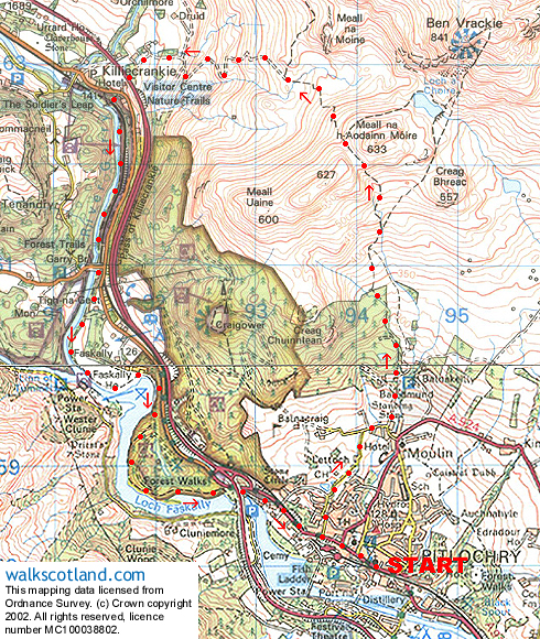
Perhaps the best starting point for this walk is the tourist information centre in the heart of Pitlochry. From there, head west along Atholl Road, passing through Pitlochry's main shopping thoroughfare which tends to be thronged with tourists or coach parties, whatever the time of year. Continue along to the far end and turn right up Larchwood Road.
A mile on from the junction, the road turns sharp left and, a short way on, reaches a junction on the edge of the hamlet of Moulin. Follow the road north to reach a small car park and continue ahead on a path heading up through the trees, a small burn down to the right. The way rises steadily to meet a track and, on the other side, continues straight ahead, this time with the stream cutting a channel through the rocks to the left.
Rising more steeply, the way climbs to meet a fence bordering an open field and track and follows it for a short distance, with Ben Vrackie (2758ft) in view up ahead. The track is joined a short distance on and followed for a hundred yards or so until the path is picked up again on the right.
It crosses the burn by a wooden footbridge and heads north through mixed woodland before following a shady ride through a plantation of larch to reach a ladder stile at the top of the woods.
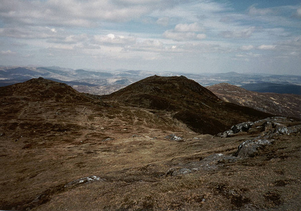
With the confines of the conifers now behind, an obvious path rises over open moorland, passing beneath a line of overhead cables. As height is gained, views open out over Pitlochry and the Tummel valley to the south. Sheep graze the hillside here but you may also be lucky enough to see grouse, roe deer and mountain hare.
The path climbs steadily to reach a junction where the route up to the bealach branches off on the left. Take this and an energetic climb rises into the col below Meall na Aodainn Moire. This is known as the Bealach na Searmoin, pass of the sermon.
Once over, the path descends over open moorland to join a track lower down. Stay on this as it curves down through a series of hairpin bends towards Old Faskally Farm where it curves left to head for Killicrankie, passing below the A9. It drops to meet the B8079 a very short distance on.
Cross the road to reach the National Trust for Scotland's Killecrankie visitor centre, which is open between April and October and is well worth a visit.
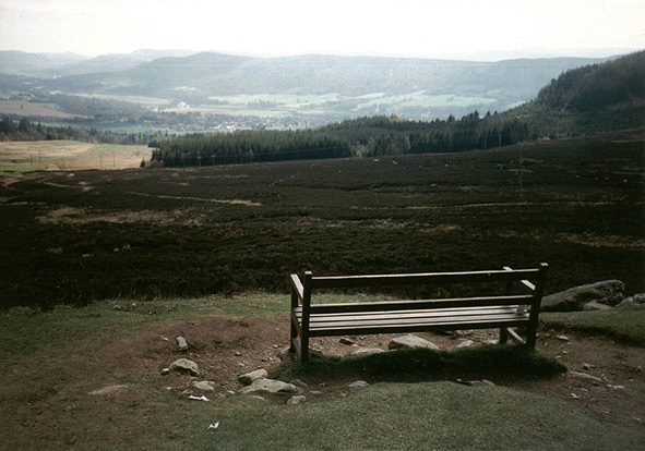
From here the walk heads south through the famous Pass of Killiecrankie, following the River Garry south and sticking quite closely to the east bank, woodland affording shelter should conditions turn inclement.
A mile from the visitor centre, the route passes under Garry Bridge and stays with the river all the way to Loch Faskally. A large kink in the in the loch takes you east before the path turns south again. The way leaves the lochside briefly, skirting by a small lochan hidden in the trees, but is soon reunited with the large body of water which not only provides recreational opportunities but also contributes to the country's power supply through the hydro-electric dam and generators further downstream.
The path passes below the A9 again before joining a track, which leads up into Pitlochry and on to Atholl Road. Follow this back to the TIC.
WALK FACTS
Distance 10 miles/17kms.
10 miles/17kms.
Map OS Landranger 1:50,000 sheets 43 and 52.
OS Landranger sheets 43 and 52.
Start Pitlochry Tourist Information Centre, Atholl Road.
Parking Public car park near railway station, next to tourist information centre, or in Ferry Road.
Public car park near railway station, next to tourist information centre, or in Ferry Road.
Grading A long walk over open moorland and through forestry with tracks and paths throughout.