Lammermuir Hills
By James Carron
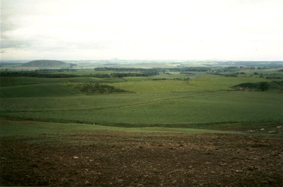
Draped over East Lothian like a patchwork blanket of browns, purples and greens, the Lammermuir Hills offer adventure in a remote landscape of low tops carved up by deep burn gullies. Only a few miles from bustling coastal towns, and the high-speed A1 Anglo-Scottish trunk road, these high, remote wilds are truly a world away.
The walk starts two miles south of the tiny village of Stenton (three miles south of Dunbar on the B6370) at a set of orange pan-tiled cottages at the end of the track leading up to Stoneypath Farm. There's space for a handful of cars above the cottages.
At the farm, bear right on a track signed to Johnscleugh. This climbs and then flattens off to reach a cottage at Moorcock Hall, and a gate ahead. Go through the gate and carry straight on, the track rising through open grazing land, with a fence on the left. It gives onto moorland at a gate at the top, and curves left to reach another gate higher up. From here, the way rises through purple heather, grass and blaeberry bushes. Skirt across Mid Hill and to the north of the flat top of Clints Dod. There are fine panoramic views over the surrounding countryside.
The descent begins beyond Clints Dod, where the ground can be wet underfoot. The track narrows past a sheepfold. Carry straight on down to Johnscleugh Farm, reaching a gate behind the buildings. Go through the farmyard and be prepared for a cacophony of barking as you pass working dogs in their kennels! On the left side of the house, reach a tarmac road. Follow this down to the valley floor. It makes a sharp right, passes through a gate and joins the road beyond Whiteadder Water.
Turn left and the single-track road rises at first before levelling off. Walk on towards a pylon line, and beyond this the way descends to a ford with a wooden footbridge. Cross a cattle grid beyond the bridge then leave the road, turning left on a track. A flat concrete bridge spans the burn.
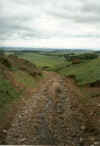
A few yards on, climb over a gate and the begin the twisting climb. The pylons veer away to the right and at the end of a long, straight uphill stretch, the track curves sharp right. Leave it and carry straight on along a path through heather, keeping a post and wire fence on your left.
Rejoin the track 500yds on, turn left and follow it towards forestry. Go through a gate, pass by a red corrugated iron shed on the left, and continue on the track to a gate entering the next plantation. Leave the track, turn left, and follow the fence up over heather and grass to a stile and public footpath sign. Cross the stile and follow a path setting off north-east through a clearing in the young trees. This leads to a track but, just before you reach it, there is a narrow burn to cross and a slightly boggy patch of grass to negotiate. Over the track, the path continues straight on, crossing the West Burn before rising through a line of recently-planted deciduous trees to a metal gate. Continue up the edge of the forest, keeping the fence to your right, to the top corner.
Turn left and follow the edge of the plantation north-west over Dunbar Common. At the end of the trees there is a cluster of wooden gates and a milestone. Cross over and carry straight on along a built-up strip of ground. At the next gate, go straight on again to another and a milepost. Follow an obvious path leading through heather, over the north-east shoulder of Deuchrie Edge.
The path broadens out and descends to an abandoned cottage at Lucknow. Continue down to a gate and climb by a stone wall to Deuchrie farm. Join the tarmac road between the outbuildings and house. Turn left at a junction onto a the single-track road leading back to the start.
WALK FACTS
Distance 10 miles/16km.
Map OS Landranger 1:50,000 sheet 67.
Start/parking Cottages below Stoneypath Farm, two miles south of Stenton (grid ref NT 614713).
Grading Obvious track and path over upland moor and low hills. Two short sections on quiet country roads.