Around Backwater Reservoir
By Colin Hogarth
For the past 30 years, the Backwater Reservoir has faithfully supplied the residents of Angus with their water. Work began on the project in the mid-1960s and the reservoir was officially opened by the Queen in 1969. The dam is 800 metres long and it holds back 25 million cubic metres of water in a man-made loch stretching over three kilometres (about two miles) in length.
The reservoir serves all the main towns in Angus as well as Coupar Angus and Blairgowrie and provides additional supplies to Dundee should the demand on nearby Lintrathen Reservoir become too great.
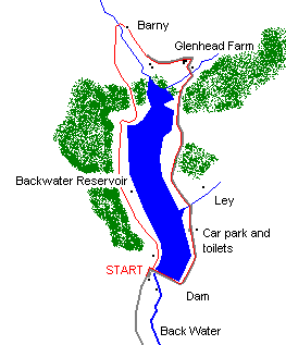
Our festive holiday leg-stretch begins at a public car park at the southern end of the reservoir. Set off north through a set of stone gateposts and follow a tarred road along the western side of the water, passing below a house a short way into the route.
The road skirts below the low peaks of Hill of Bellaty and Creag Feamhar, disappearing into woodland, just beyond a wooden chalet down to the right. As the way emerges back into the open, a gate and stile mark the start of a section through an open field where sheep are usually to be found grazing.
At the far end of this grazing land, the track curves right. At a stand of tall trees, the way forks, the more obvious route curving left up towards forestry and a gate. Don't take this route, but follow a less obvious grassy track on the right. This leads into an open field, sloping down to the water's edge. As a lone tree is approached, bear left up to an obvious gate on the edge of the plantation above.
Inside the woodland, a grassy path scattered with pine needles and rotting fallen branches, heads north, sheltered by the tall trees. It emerges into the open again on the northern edge of the plantation at a rather ramshackled gate.
An obvious but rutted path continues north above open fields. A couple more decrepit gates have to be negotiated as the route descends gently towards a bridge over the burn, in view up ahead. The ground immediately before the bridge can be very marshy.
Once across, bear right over an open field towards a byre ringed by a wall of stone, just below the white cottage at Barny. Aim for this vacant dwelling, joining a track immediately in front of it.
Turn right and head south east. Beyond a couple of metal gates, the track runs through a farmyard and skirts the southern flank of Cuilt Hill to reach Glenhead Farm. The route then curves sharp right, dropping past a farm shed on the left to cross the Hole Burn.
A quiet, single-track road heads south, following the eastern shore of the reservoir, back to the dam.
WALK FACTS
Distance 6 miles/10km.
Maps OS Landranger 1:50,000 sheets 44 and 53.
Start Backwater Reservoir dam car park.
Parking Large free parking at start, with public toilets.
Grading An easy, low level walk following well made tracks, paths and a minor road round
Backwater Reservoir. Some sections can be wet and muddy underfoot, so wear
stout footwear. Dogs should be on the lead due to sheep and cattle grazing.