Farmland and Foreshore
By Andy Crawford
The Kingdom of Fife has some of the most picturesque towns and villages to be found in Scotland and the East Neuk in particular is steeped in history. Very popular as a holiday resort, there is an abundance of quiet secluded spots for relaxation, spectacular sea views, family walks etc. The local people are very friendly and inviting and many of the events and galas held in the area throughout the summer are great tourist attractions.
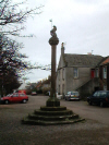
From the car park, walk east away from the Tollbooth past the Mercat Cross and left into Denburn Wood - a delightful little den with a burn trickling through it. Look out for the Rude Well ' a baptism or scholar's well - a bottle-shaped, medieval well rediscovered during excavations in 1972. This has a religious link with the Auld Rude of Karail ' the pre-Reformation Cross in the Kirk ' and with baptisms. In later ages it was associated with the scholars from the grammar school which once stood by the old manse in Marketgait.
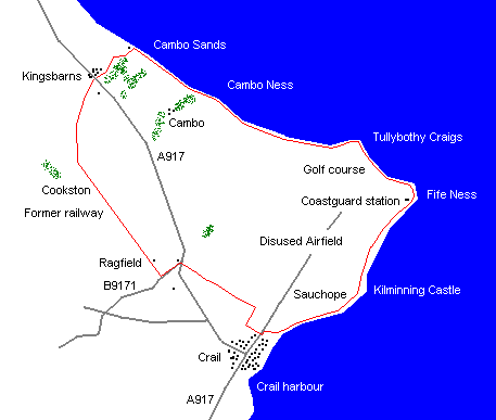
Keep on the path down by the burn then follow it up to the car park by the old cemetery. Turn right here and walk up a short stretch of road past the new cemetery and a barrier onto a rough track leading towards the caravan site. Keep left on reaching the first of the caravans. This path goes on through a pleasant mix of cultivated land and livestock pasture, up to the garden boundary of Smithfield where it bears sharp left then emerges by the side of the A917 St Andrews to Crail road at Chance Inn.
Cross over carefully on to the B9171 and walk straight on to the old railway bridge where a Kingdom of Fife Millennium Cycleway sign indicates a 'circular' route going off to the right. Follow this up the wide track past Ragfield, beside the course of a former railway.
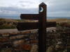
At GR 584109, approximately 400 metres past the ruins of Cookston, and before reaching a bridge across the track, a low wall breaks to the right. Follow the narrow footpath to the left side of this wall towards a strip of trees, taking in spectacular view north-eastwards over St Andrews Bay. At the trees, the ancient church spire in the village of Kingsbarns comes into view above the rooftops. At the end of this path is the A917 ' previously crossed at Chance Inn. This now has to be crossed first right and then left into Back Style - once known as Sea Road ' down to the beach car park. There are one or two misleading finger-post signs beside a gate on the right at the end of the road that indicate a walkers' route which leads onto the Kingsbarns Links golf course. These should be avoided. Continue a short way on to the car park before turning right on to the marked Fife Coastal Route and follow a wide sandy path between the beach and the golf course. Keep as close to the red 'water hazard' marker posts as possible.
The coastal path markers are a little confusing in their numbers at the end of the beach. Turn right into the trees, and cross an elaborate new bridge. A short way on is an alternative 'High Tide Route'. It is strongly recommended that walkers follow this as there is no way round a small headland which lies a short distance ahead when the tide is in. If the tide is out, follow the path close to the right hand side of the low wall, which then takes a twist through a gap so it is then on the right. A signpost indicates a route change along the seashore. It directs walkers to another marker beside a wall. Once over the wall, continue ahead through an open field, around the small headland on the foreshore and follow the narrow track alongside the fence. If in any doubt about negotiating the headland, head up the steep grass bank on the right to the fenceline where there is a narrow footpath that can be followed with care.
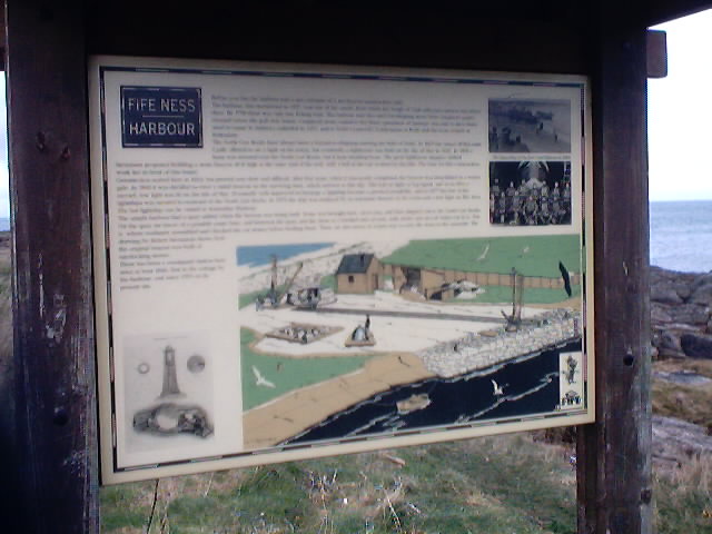
The path leads alongside another golf course ' Balcomie Links ' following the white 'out of bounds' marker posts to the site of the old Fife Ness Harbour where an information board describes the construction and history of the beacon light which once stood on the North Carr rock a short distance offshore and the lifeboat which was once stationed nearby. The North Carr lightship that marked the outermost part of Fife Ness is now berthed in Dundee.
In a storm in December 1959, the lightship broke her moorings and was in danger of being driven onto the rocks with potential for loss of life. The RNLI lifeboat Mona, stationed at Broughty Ferry, was launched but in the dark of night, while heading out over the bar of the River Tay, she capsized with the loss of all her crew. The lightship was eventually saved without loss of life or injury to any of her crew but she never returned to station.
Follow the path around the headland below the HM Coastguard Station and lighthouse then through Kilminning Coast Wildlife Reserve, managed by the Scottish Wildlife Trust, where an information board gives details of the kind of birds that can be seen. An obvious footpath leads along this stretch of the coast and through Sauchope Caravan Site.
At the end of the road follow the Fife Coastal Path sign up and along the path between two fences, past a row of recently built houses. Continue on the upper footpath, then turn right at the first junction into Roome Bay Avenue. This leads out near to the entrance to Denburn Wood. Turn left and walk the short distance back to the start.
WALK FACTS
Distance 10.3 miles/16.5km.
Map OS Landranger sheet 59.
Start/parking Car park off High Street, Crail, beside the Mercat Cross and Tollbooth. GR: NO 613078.
Grading Good paths and track with a little road and foreshore walking. Much of the walk passes through agricultural land and dogs must be kept on the lead and under strict control. When walking beside the golf course, keep close to the marker posts and do not venture on to any part of the course. Stop to allow the progress of play where necessary.