Railway ramble to Loch Tay
By Colin Hogarth
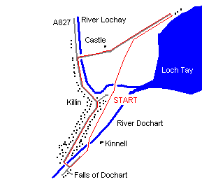
The trackbed of the former Killin Branch Railway provides a good footpath for an exploration of some of the local sites, including an historic castle complete with beheading pit and the famous Falls of Dochart.
The railway line is picked up behind the public toilets in the car park. Up until the 1960s the village station and goods yard were to be found here. Once on track, turn left and follow the line along behind a council depot to the River Lochay where a relic of the railway, an old iron bridge, spans the water.
On the opposite bank turn right, passing through a gate to pick up a path along the grassy, tree-lined bank of the river. This is grazing land and if you have a dog it should be on its lead. Stay close to the water's edge, enjoying views of the Meall nan Tarmachan ridge to the north, to the southern end of Loch Tay where a line of fat old oak trees leads back to the railway line, reached just beyond a kissing gate.
Turn right and follow the flat trackbed east through the trees to Loch Tay Station where, during the early years of the branch, a pier extended out into the loch, serving cargo and passenger steamers. All that remains today is the wooden station building and platform, now a private house, and just beyond it at Cory End the white house you can see occupies the site of the engine shed.
The five-mile-long branch opened on April 1, 1886, and its construction was funded by villagers and the local landowner, the Marquis of Breadalbane. Trains puffed up and down the track until September 27, 1965, when a rockfall in Glen Ogle closed the line between Callander and Crianlarich and the branch. This happened just a few weeks before Dr Beeching's axe was due to fall.
A minor road runs parallel to the trackbed back towards Killin, passing by the ruin of Finlarig Castle which dates from the 11th century and sits up to the right at the edge of the woodland. Set in the wall above the main door is the coat of arms of James IV and the date 1609 and on the other side of the building is a shallow rectangular hole over which enemies had their heads chopped off! Hidden in the trees close by is the ruin of a mausoleum and the grave of the marquis.
Continue on the minor road to meet up with the A827, then turn left and follow the main street through the village to the Falls of Dochart. Fuelled by autumn rain, the falls crash down through Killin, the gurgling torrent cascading over water-worn rocks before channelling down beneath the road bridge which dates from 1760.
Before you cross, the Breadalbane Folklore Centre, housed in St Fillans Mill, built in the 1840s as a corn mill, is well worth a visit. It houses an exhibition on St Fillan, a preacher and healer who came to the area at the end of the 7th century, and is open daily to November 5 and then at weekends only through to the end of the year.
Across the bridge the railway line is picked up again by turning left and passing through the gates of Kinnell Estate, with the impressive five-arch Dochart viaduct the next port of call. Cross this then drop down to the right where a footpath runs along the grassy bank of the river, turning to follow the River Lochay back up to the car park.
WALK FACTS
Distance 3 miles/5km.
Map OS Landranger sheet 51.
Start/parking Public car park in Killin at GR NN 575333. A minor road off the main street opposite the village newsagent leads to this. Plenty of free parking at start.
Grading Easy low level walk in and around the village of Killin using path, track and a stretch of quiet minor road. Some stretches of riverside path can be muddy after rain so stout footwear required.