Blair Atholl to Bruar Lodge
By Colin Hogarth
The Perthshire village of Blair Atholl - with its famous castle - is the starting point for this lengthy day walk into the upper reaches of Glen Bruar.
The route begins near Old Bridge of Tilt and heads through the glens of Banvie and Bruar, returning from Bruar Lodge - the most northerly point on the walk - via the old Minigaig road.
From the car park, head out on to the road, turn left and, at a junction a short walk on, where a track forks left, stay on the road as it bears right. It climbs between open fields to a crossroads. Go left here and follow the road down through Old Blair. The route bears sharp right and descends to cross the Banvie Burn by an old stone bridge. Take a track on the right a little way on and follow this up past a steading.
The way rises through trees, the burn gurgling down through a gorge below to the right. Carry straight on along the track, which levels off in due course to reach a junction where a track branches right to cross the river by a stone arch bridge. Don't take this, but walk straight on and, in half a mile or so, the way reaches the edge of the forest.
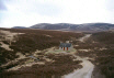
Cross a stile here and follow the track up Glen Banvie. It skirts the edge of the plantation and, two miles on, re-enters the trees. As it begins to curve left, branch right on a path below Sron Dubh which leaves the trees and heads north-west to a ruined cottage at Ruichlachrie. A short walk on from here, it fords the Bruar Water.
There is no bridge over the stream - which in normal conditions is shallow at this point - and it must be waded. The best idea is to take socks off, replace boots and then paddle over.
Once across, follow the route up to join the main Glen Bruar track at the boarded up cottage of Cuilltemhuc and turn right. The way heads north up the valley to lonely Bruar Lodge, three miles on.
Cross the bridge below the remote dwelling, a working sheep farm, and bear immediate right along a path that skirts between the grounds and the river. It follows the east bank of the Bruar Water south before rising over open ground. This part of the route follows the ancient Minigaig road that ran from Blair Atholl to Kingussie.
A mile and a half from Bruar Lodge, the path descends to reach the open bothy at Allt Sheicheachan. The former stable provides shelter and a good spot for a lunch break or breather.
From here, head south on a good track that climbs away from the bothy and skirts south-east around the flank of Meall Tionail. It descends to a bridge over a burn before curving right to head down the open glen. Below, the way bears left and drops to cross the Allt na Moine Baine and, a short way on from here, it passes a prominent cairn.
Stay with the track as it descends into Glen Banvie to reach the edge of the forest. Cross a ladder stile and, once in the plantation, continue straight ahead through the trees. At the next junction you reach, go right and the track leads to the old stone arch bridge encountered earlier in the day. Retrace you steps from here through Old Blair to the start.
WALK FACTS
Distance 16 miles/26km.
Map OS Landranger sheet 43.
Start/parking Public car park 200 yards west of Old Bridge of Tilt (grid ref NN 874663). To reach this follow the B8079 into Blair Atholl and follow the minor road north, signed for Old Bridge of Tilt. Go left at Old Bridge of Tilt, cross the bridge over the River Tilt and the entrance to the car
park is on the left a short way on.
Grading A long full day route suitable for fit, well equipped hillwalkers through some fairly remote countryside, best done on a good summer day. There is track and path throughout but one fairly shallow river crossing with no bridge - the water must be waded and great care taken. Sheep graze
Glen Bruar where dogs will need to be on the lead.