Dubh Loch from Loch Muick
By Colin Hogarth
Eagles' Rock - a name straight out of an Alistair MacLean novel, a dramatic coastal bluff, perhaps, ready for a battle-hardened wartime hero to abseil off, en route to blowing up an enemy bomb-making factory and saving the day. The Eagles' Rock on this route may be impressive, but it probably doesn't have such literary pedigree. Instead, it stands guard over Dubh Loch, a peaceful stretch of water beneath the White Mounth, and destination for this walk.
Set off from the public car park at Spittal of Glenmuick, at the end of the public road in from Ballater. The track descends over a bridge and passes a picnic area and public toilets to reach a small ranger centre, housing an exhibition of local flora and fauna and an interesting relief map of the surrounding country. The displays give a pointer to some of the wildlife you can hope to see along the way. Red deer are among the more common attractions, while more rare creatures to look out for include red squirrels and, on higher ground, ptarmigan and golden eagle.
Carry straight on, round a chain gate beyond the ranger centre, and follow a wooden sign for the Loch Muick circuit. Stay on the track and ignore a track on the left signed for Capel Mounth.
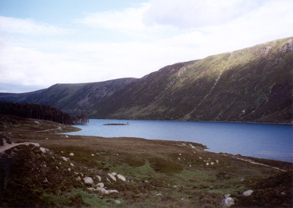
A little way beyond this junction, a wide path branches right and descends to a wooden footbridge over the River Muick. Cross and walk round the north end of the loch, skirting above some fine sandy beaches, to a boathouse. A path joins a good track. Go left and follow this along above the loch. There are excellent views down the glen and across Loch Muick.
The track approaches forestry surrounding the Royal lodge at Glas-allt-Shiel. A path on the right leaves the track and rises gently through tall Scots Pine trees, skirting behind the lodge, to a bridge. Cross and continue on the path as it curves left to meets up with the loch again on the far side of Glas-allt-Shiel. This detour avoids encroaching upon the lodge, sometimes used by the Royal family when they are staying at Balmoral.
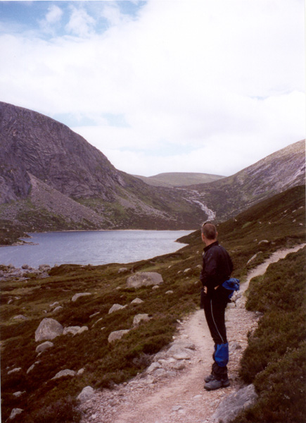
A wide path continues along the lochside. Follow this for a short way until you reach a path branching right and take this. It rises gently away from the water, climbing into the glen between Broad Cairn, to the left, and the White Mounth, on the right.
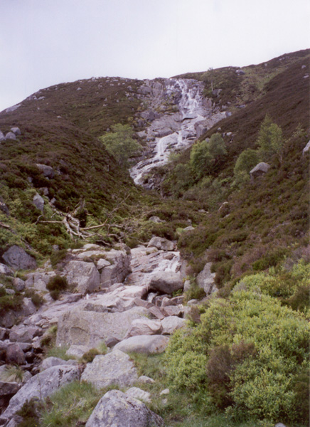
Two kilometres from Glas-allt-Shiel, the path crosses a stream below a waterfall, fed by Loch Buidhe, concealed in a coire above. There are stepping stones to take you over the burn and, once across, the path continues to climb, bearing left to meet the Allt an Dubh-loch. The burn tumbles down over exposed slabs of rock and there are some fine little waterfalls.
The path continues to gain height almost until Dubh Loch is reached. The remote expanse of water sits in an amphitheatre of rock, steep broken crags rising south towards the summit of Cairn Bannoch. To the north is Eagles' Rock - where you may be lucky enough to see the bird from which it takes its name.
The path becomes a rather marshy and muddy affair as it progresses along the lochside, but extending the walk to the northern end of Dubh Loch is worth the effort for the sandy beaches that nestle there.
From Dubh Loch, retrace your steps to Glas-allt-Shiel and return along the track to the start, via the boathouse. Alternatively, you can make your way back to Spittal of Glenmuick via a path and track on the south side of Loch Muick.
WALK FACTS
Distance 10 miles/16km.
Map OS Landranger sheet 44.
Start/parking Spittal of Glenmuick (grid ref NO 310853). There is a £2.50 parking charge levied, with the money raised going towards access improvements, such as footpath repairs.
Grading A low level track and path walk with a fairly strenuous section of ascent to Dubh Loch, suitable for fairly fit adults and older children. The estate requests that dogs are kept on the lead.