The Deil's Caldron
By Colin Hogarth
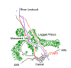
Venture into the countryside north of Comrie and discover dramatic waterfalls, peaceful woodlands and impressive views on this walk up Glen Lednock.
From the car park, head west, crossing a wooden footbridge over the River Lednock, turn right and a path follows the course of a former railway line along the back of the Comrie. It joins a gravel drive at the far end and this meets up with the public road leading past the village primary school, a short walk on. Continue straight ahead, by a car park on the left, and at the next junction turn right on to Dundas Street.
The road leads north and when it curves left (signed to Crianlarich) go straight on, a single track road leading into woodland. Just beyond the single track road sign on the left, turn right between a set of stone gateposts, following a sign for Deil's Caldron.
The path heads through tall beech and oak trees with a field of grass on one side and, after a straight stretch, it bears left. Walk on through the woodland and, as you gain height, the river nears, the sound of the gushing torrent the first indication of its presence.
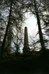
The River Lednock soon looms into view, coursing down through a rocky channel almost concealed by the heavy tree cover carpeting both sides of the glen. Lord Melville's Monument, a huge square column of stone sitting atop Dun More, can be glimpsed through the trees as you go here.
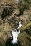
Part way up a short detour leads to a viewpoint above the Wee Caldron, a deep pool of water below a small waterfall. Back on the main route, the path rises quite rapidly to meet the single track Glen Lednock road where a path runs parallel to the tarmac. It passes a bricked up shelter, then a wooden walkway leads to steps leading down to a viewing platform above the Deil's Caldron, a steep staircase of turbulent white water eating its way into the rock. The best spot to see all of the falls is the far right hand end of the wooden balcony.
When you've finished here, climb to the top of the steps to join the road, then turn right and walk a short distance to the start of the path up to Lord Melville's Monument, on the left.
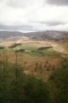
It is a steep climb through the dense coniferous woodland but the effort is well rewarded when you emerge on the summit of 840-foot high Dun More and marvel at the views south over Comrie and the Earn valley.
The monument was built in 1812 to mark the death a year earlier of Henry Dundas, 1st Viscount Melville and Scotland's Lord Advocate from 1775 to 1783. He had a country home at Dunira, two miles west of this spot.
Return to the road from the monument and continue north to a track branching off on the right. This leads down to 'Shaky Bridge', over the River Lednock. The choice of name is a bit of a mystery as the bridge is not particularly shaky.
The return leg begins here, the path hugging the river bank before it rises up to enter Laggan Woods, a mixed plantation dominated by Scots Pine, larch, Norway Spruce and Douglas Fir. Remnants of the original oak and birch woodland are still to be found and wildlife inhabiting the trees include red squirrels and roe deer.
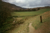
From the kissing gate at the top end of the plantation, the path is well signed through the trees and there is a good view across the glen to the monument at one point.
The path rejoins the River Lednock lower down at a weir and follows the flow back to the start.
WALK FACTS
Distance 4 miles/7km.
Map OS Landranger sheet 52.
Start Laggan Wood car park, Comrie. GR: NN 776224. There is an information board and a free leaflet published by Perth & Kinross Council is usually available here.
Parking Car park is located on the east side of Comrie, close to the River Lednock. Turn off the A85 at sign for Comrie Golf Club and car park is first left.
Grading Sheltered glen walk rising to open hillside with strenuous optional ascent to hilltop viewpoint and monument, an excellent picnic spot.