

Hill of Cat
By Colin Hogarth
The Fungle Road and Firmounth Road are two ancient highways linking Glen Esk in Angus with Deeside in Aberdeenshire. Dating from around the 13th century they were busy trade routes in their day. Now, however, they are the preserve of hillwalkers and this route to the summit of Hill of Cat offers a taste of both.
Starting in the hamlet of Tarfside, head out of the car park on to the road, turn left and follow the tarmac a short way to join a track on the right just before the bridge over the Water of Tarf. There is a green Scottish Rights of Way sign at the junction indicating the start of the Fungle and Firmounth roads.
The way runs through a small patch of woodland before head out across open moor. It undulates over open hillside, before dropping quite steeply to a bridge spanning the Burn of Tennet. Cross and carry straight on, climbing to a junction. Bear left here, following another Fungle Road sign over pasture where grazing cattle are often to be found.
The way is grassy underfoot and rises to a cottage at Shinfur. It skirts to the right of a stone outbuilding before curving round the front of the isolated house. From here, the track descends to cross the Burn of Clearach, before beginning the ascent of Tampie, the first peak of the day.
The route of the Fungle Road is well graded and although height is gained quite quickly up the long heather-clad flank, the walking is not too strenuous. The track kinks part way up and a mile beyond this point a junction is reached. Here the Fungle Road heads over the col to begin its descent to Aboyne. Our route leaves this ancient right of way and follows the old Firmounth Road instead. Bear left at the junction and the track rises through a couple of wide bends, curving between grouse butts. The ascent is initially quite steep but it soon eases off, passing a number of cairns before reaching the pile of rocks marking the 723 metre high summit of Tampie.
Continue north along the Firmounth Road into the col between Tampie and Gannoch. A couple of small lochans are marked on the OS map, but these are little more than marshy bogs. From here, the way starts to rise once again. Go up a short way until you spot a line of tall metal fence posts, then bear left, leaving the Firmounth Road, and follow these to Hill of Cat.
At one point this must have been quite an impressive boundary line, the slender stakes interrupted at intervals by much more solid cast iron poles. However, it has all fallen into a state of disrepair and while the rusty posts and broken wire are not the most attractive of features, the fence line does offer a handy navigational aid, particularly if the mist is down.
In the bealach below Hill of Cat some rather marshy spots amid the black peat hags must be negotiated. But as the slope embarks upon its upward trend, a reasonably good, if narrow, path accompanies the forlorn fence right up to the trig point on the summit of the 742 metre high peak.
Excellent views roll out north over Deeside and south across Glen Esk. Mount Battock, a Corbett, can be seen to the east, while Mount Keen, a Munro, is over to the west.
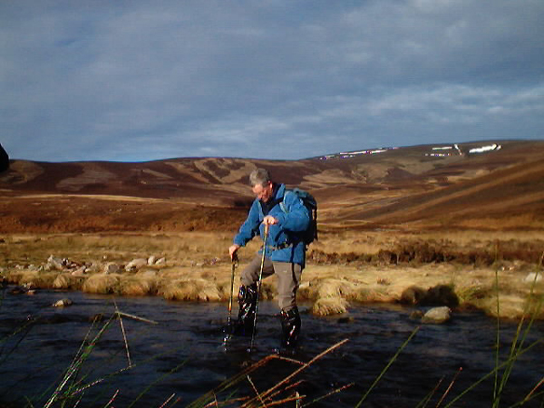
Leaving the security of the fence behind, descend south-west over Hill of Corn to pick up an obvious track below. Follow this south into the Burn of Cat glen to reach a ford in the Water of Tarf. The best way to overcome this obstacle is to head downstream a little way to a point where the river splits and an easy crossing can be made.
Return to the track and continue south, passing by Baillies and then the cottage at Burnfoot, a mile or so further on. The way leads back to Tarfside, approaching the village by the charming Episcopal Church, fine granite architecture set amid neatly mown lawns. Join the public road a little way on from here and follow it east back to the car park.
WALK FACTS
Distance 11 miles/18km.
Map OS Landranger sheet 44.
Start/parking Public car park in Tarfside. GR: NO 493797. There are public toilets here.
Grading A long walk with good track and path for the majority of the route. Some sections
involve crossing animal grazing land where dogs should be on the lead. The
route also crosses moor used for grouse shooting so during the season
(August 12 to December 10) its worth checking with the Millden Estate
before you set off, unless you go on a Sunday when there is no shooting. There is also deer stalking on the estate. The head keeper's number is 01356 670267.
Photos by Andy Crawford