The bridge at Bachnagairn
By Colin Hogarth
Seeking out the beating heart of a waterfall lost in an ancient forest of Scots Pine trees is one of the true pleasures of venturing into the countryside.
Combine this with a walk through a remote glen where craggy hillsides loom ominously overhead and you have a real walk on the wild side.
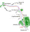
Setting off from the public car park in Glen Doll, this route rises to the early outpourings of the River South Esk at Bachnagairn, where a sturdy bridge stands as a lasting tribute to a hillwalker and mountain rescue volunteer who died in a climbing accident just a few miles from this beautiful spot.
The small visitor centre in the car park is well worth a visit before you head off. It houses information on the local area, plus details of some of the flora and fauna you may be lucky enough to spot along the way.
Leave by the south end of the car park, turn left on to the access road and follow it back to the concrete road bridge over the bubbling River South Esk. Cross and, on the far side, bear left through a gate and follow the track along above the east bank of the river.
The way runs through open countryside initially, with blankets of forestry up to the right. It enters woodland further on, passing by the Glen Doll end of the old Capel Mounth road that leads over the hills to Ballater.
Continue north on the track, passing through a high metal gate, and in due course it leaves the trees and heads over open land to Moulzie, a small steading overshadowed by the brooding cliffs of Craig Broadlands.
The route skirts right, passing above the cottages, before dropping down to a junction a short walk on. Leave the track here - it curves left down to the river - and branch right on a path leading towards another plantation of conifers.
The way curves left, crossing some rather basic log bridges before skirting along the bottom edge of the dense plantation. Further north it meets up with the river, arriving shortly at a wooden bridge over the white water.
Cross and rejoin the track on the other side. Go right and the route turns west below the rock-strewn buttress of The Strone. From here on up, the glen feels remote and isolated, steep, rocky slopes rising boldly to planed-off hilltops.
The track gains height more purposely, occasional trees building up to a patchy woodland of Scots Pine below Bachnagairn.
Higher up the stony way narrows to a path that twists up through the trees, crossing two ladder stiles, before finally reaching the Roy Tait Memorial Bridge, a solid wooden structure spanning the Burn of Gowal. Below, white tails of water whip the bare rock, dark pools lurking in deep fissures.
The bridge was built in 1984 to commemorate the life of Roy Tait, a member of the Grampian Club and Tayside Mountain Rescue. He died three years earlier on Lochnagar.
Over the bridge, the path curves up the hillside and it's worth climbing just a little higher for fine views down the glen. Enjoy a picnic by the bridge before setting off back down the valley, retracing steps to Glen Doll.
WALK FACTS
Distance 8 miles/12.8km.
Map OS Landranger sheet 44.
Start Forestry Commission car park at Glen Doll. GR: NO 284762.
Parking Large public car park with visitor centre at the start. A parking charge (£1) is levied.
Grading Relatively undemanding walk through a low-level glen to a waterfall with track for the majority of the route and path for the remainder. One section of the route can be quite muddy underfoot. In cold winter weather, watch out for ice on parts of the track below Bachnagairn. Except within the forests, dogs should be on the lead.