Hill of Fare
By Andrew Jarret
Standing in relative isolation from the farmlands north of Banchory, the flat-topped Hill of Fare contains a remarkably large area of moorland plateau and sends a number of shoulders far out into little wooded glens.
At 471 metres, or 1545 feet, high it may be only 'half' a Munro but the peak still provides a full mountain experience. For its relatively modest height it forms an unusually complex hill, it's almost like a mountain range in miniature, and gives superb views of Deeside. The usual route to Hill of Fare from Banchory goes through a marshy depression occupied by reeds and willows near Lochhead House.
The damp terrain is a reminder that this area was formerly occupied by the Loch of Leys before the land was drained for agriculture.
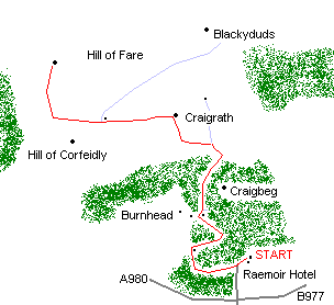
There are a multitude of tracks leading to the Hill of Fare in this area but a good way up is found near the Raemoir Hotel. This interesting route goes south west from the hotel, then west, then curves in a northerly direction up past an old castle at Cluny, winds through the woods at Burnhead, then follows a hill road which climbs its way up Craigrath via a left hand branch in the track at The Skairs.
The route eventually emerges on the wide summit plateau about six and a half kilometres (and roughly 380 metres ascent) from your starting point. The highest summit is the one to the north west.
Another fine way up comes from the north side, starting at grid ref 703 058, past the old castle of Midmar and Craigshannoch above the Gormack Burn. The route follows forest roads and then an old peat track to Tornamean and on to the summit. To the north east of the Hill of Fare, the little hill of the Barmekin near Echt gives equally grand views of the surrounding low country and has the added attraction on an ancient hill fort on its summit.
WALK FACTS
Distance 8 miles/13 km.
Map OS Landranger sheet 38.
Start/parking The Raemoir Hotel near the junction of the B977 and A980 north of Banchory. GR: NJ 696995.
Grading Suitable for fit walkers of all ages. A degree of navigational skill is required in the woods so remember to pack a map and compass.