Traversing the Lomond Hills
By James Carron
Separating Fife's rural north and urban south, the Lomond Hills are a natural barrier between the scattered country communities, open fields and forestry on one side of the divide and the ever-expanding towns, retail parks and industrial estates on the other.
Despite its proximity to population, the upland area retains a sense of wilderness, with vast tracts of open moorland, quiet woodlands and prominent peaks from which the walker might catch a glimpse of distant industry but still revel in the great outdoors.
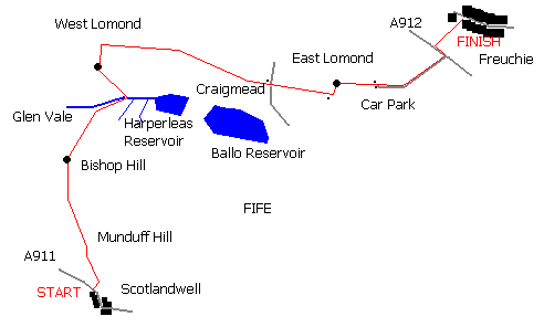
The route starts on the main road through the tiny village of Scotlandwell, south of the church, where a sign for Bishop Hill points the way. Wooden steps rise from the pavement and the path climbs to a stile a hundred yards on. Cross and turn left, following a fence north.
The path rises gently to meet a more substantial way on which you turn right, to climb past gorse bushes. After a concerted uphill pull through Kilmagad Woods, the path turns left, skirting the hillside to gain height more gently. Continue up through a small wooded area to a stile straddling a stone wall.
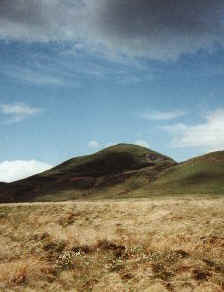
The summit of Munduff Hill is obvious ahead and there are fine views over Loch Leven. Cross the stile and a path strikes north over a flat section of hillside. Just before the slope steepens again, it curves right below a quarry and crosses the hillside to meet a wall and fence. The path climbs by the wall all the way to the summit. Bishop Hill is visible to the north, as are the two Lomond Hill tops, the prominent rounded mound of East Lomond and its slightly higher, bulkier companion, West Lomond.
A narrow path runs down Munduff Hill's north flank and over open grassy moorland to meet and follow a track north to a point where several walls converge. Pass through the first gateway but don't follow the track, which veers west. Instead cross a wooden gate on the right and a path leads from here to Bishop Hill. There is a stone wall to be crossed before you reach the summit cairn. Again excellent views are the order of the day.
Continue north over open hillside. After a mile, on the escarpment to your left is a 40 foot high basalt column called Carlin Maggie. According to local lore Maggie, a witch, had an altercation here with the devil who unleashed a bolt of lightning, turning her to stone.
In due course the path drops into Glen Vale. The deep valley is known as the Covenanter's Glen. During the 17th century exiled ministers were said to have held secret services in caves here. Bear right into the glen to avoid losing too much height before the ascent of West Lomond.
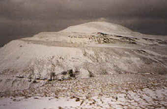
A path runs east through Glen Vale towards Harperleas reservoir and a route to the top can be found. It rises from one ladder stile to another before skirting west along the hillside, where a steep narrow path leads directly to the summit at 1713ft.
West Lomond, site of an ancient fort, is a fine viewpoint from which to survey the Kingdom of Fife. Urban sprawl and industry spread south to the Firth of Forth while to the north and east is the fertile and less heavily populated Howe of Fife. Further north the hills of Perthshire are visible on a clear day.
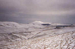
A path drops down the north side of West Lomond, running below the top to strike east over open heather and grass moorland, leading to Craigmead car park where there are toilets, information boards and a pleasant picnic area amid tall trees.
Cross the minor road bisecting the Lomond Hills and a good track stretches out towards East Lomond. Just below the summit of the day's final hill there is an old lime kiln with a short trail and information boards around it. Limestone quarrying was once a thriving industry on the Lomond Hills. The stone was cut from the ground around the kiln, resulting in strange undulations in the carpet of heather, and processed on site.
Back on the main track, pass through a kissing gate on the left - a sign points the way - and an initially easy slope quickly gives way to a steeper climb to the summit. Lead-soled shoes as worn by deep sea divers would be a handy accessory on East Lomond as it can be difficult staying upright in the strong winds which frequently howl over this exposed summit.
Descend east on an eroded path to the hillside car park by a compound of telecom aerials and dishes. There are toilets here. Follow the minor road down through the trees to the main A912. Cross, turn left and follow the roads a short way to join a path which leads to Freuchie, a little under a mile on.
WALK FACTS
Distance 10 miles/16kms.
Maps OS Landranger 1:50,000 sheets 58 and 59.
Start/parking Scotlandwell (NO 185016).
Finish Freuchie.
Public transport Fife Scottish (Tel 01592 610686) operate bus services to Scotlandwell and Freuchie.
Grading A challenging route for fit walkers.