Between Clova and Prosen
By Colin Hogarth
This is an 11 mile trek over a little-walked upland route riding the border between Glen Clova and Glen Prosen in Angus.
The hamlet of Dykehead is where the roads from Glen Prosen and Glen Clova converge. A bundle of cottages clusters round the village pub, for many years the source of sustenance for the scattered outlying farms and crofts. In recent years efforts to re-populate the area have seen a small development of homes added to the community. The main road continues north into Clova, but we break off and head west through the pass between Tulloch Hill and Mile Hill. There are two start points for this walk. The first is a track end about half a mile from Dykehead, just before the road passes a tiny lochan. Alternatively drive on for half a mile and park in a small layby just after the road turns sharp right.
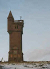
The two tracks rise through a forest of tall Scots Pine trees before joining for the final short pull up to the Airlie Memorial Tower. After years of viewing this prominent monument both from the road and from surrounding peaks, I felt the time had come to view it close up and there lies the inspiration for this walk.
It didn't disappoint. As you approach, picture yourself pulling up the driveway to a country mansion house. Tantilising glimpses can be snatched through the trees but it's only when you emerge from the forest that you get a good clear view of the tower, solid blocks of stone rising up to a castellated platform and a small tower-let on one corner. A set of steps bordered by shrubbery lead to the solid metal front door. Unfortunately this is locked to keep the inquisitive out, which is a shame as the view from the top would doubtless be fantastic. You have to settle instead for a look at the well preserved carvings set into the masonry on both the front and rear elevations. The monument was erected in memory of the 10th Earl of Airlie who was killed in action in the Boer War.
With the tower finally discovered, it's time to get down to the serious job of walking. Head north over open hillside, a good track leading to a high gate and ladder stile a short way on. The forestry over the next stretch has been recently felled, offering the walker uninterrupted views to bulky Cat Law on the other side of Glen Prosen on the left, and Glen Clova down to the right.
The way descends a little from the summit of Tulloch Hill before rising up to pass through an opening in a drystane dyke. You enter the trees here and the path skirts left below another low top before gently dropping into the wide dip ahead of The Goal, quite an apt name for a hill you're setting out to reach the top of. There are trees left and right here, but the path strikes off (pardon the football pun) through a wide heather-carpeted clearing. The way stays close to the plantation on the left rising gradually over the well graded slope before the summit is netted.
The path follows a fence north from here over a wide, open stretch of moorland, curving left to reach a point where various fences converge. The track bears left. Leave it behind, go through a wooden gate and let the line of a post and wire fence riding the wide flank ahead guide you over the heather to another track a short distance on.
Turn right and the route descends into the col before climbing up to stony Craigs of Lethnot. The way skirts to the right below the summit, following the fence on towards the barren top of Hill of Counternach.
Throughout the walk you remain well placed to snatch views into both Clova and Prosen. Cat Law remains the dominant feature to the south west while Ben Tirran sits almost directly north. The craggy bowl of Loch Wharrel, popular with pike fishermen, is well defined to the left of this Corbett.
Descend over Hill of Balbae, then there's a more honest drop to the rounded hump of Cairn Leith. Ahead are uninterrupted views to the arcing ridge of Cairn of Barns and, above it, Cairn Inks and Hill of Strone.
From Cairn Leith, descend south west into Glen Cally, tramping over soggy grass and heather. Head towards the burn in the base of the valley and follow this down, in the shadows of the hills climbed on the outward stretch. You can either stay with the burn, hopping back and forth over the twisted flow as it evolves from a tiny trickle to a fully fledged stream, or haul yourself up the western slope of the glen to find a path. Go quietly and you may be lucky enough to spot fairly substantial herds of red deer combing the slopes above.
Glen Cally plops you back out into civilisation when the path reaches the public road at a little stone bridge below the cottage at Buckhood. Cross over and follow the peaceful rural highway south, past the house at Glencally and a collapsing stone barn on the other side of the tarmac. The latter is the sort of country property that is just crying out to be renovated into a quiet country retreat for some country lover looking for a tranquil spot to settle.
The road continues south back to the start. It is flanked by commercial forestry on the left and, to the right, steep, grassy, rabbit-infested fields plunging down to the lively Prosen Water in the base of the glen.
WALK FACTS
Distance 11 miles/18kms.
Map OS Landranger 1:50,000 sheet 44.
Start/parking Small layby opposite Glackburn in Glen Prosen (grid ref NO 372606) or track end close by lochan below Mile Hill (grid ref NO 377607).
Grading A straightforward route over low open hills with path and track for much of the way.