Roaming in Rannoch
By Colin Hogarth
The extensive forestry plantation rising from the south shore of Loch Rannoch combined with the surrounding mountainous country provides the setting for some great walks and mountain bike routes. Away from the marked path for walkers, the tracks are hardly ever touched.
Breaks in the trees along the way offer spectacular views and keep an eye open for wildlife. One of the most interesting sights is the armies of ants you'll see busily creating their giant nests from discarded pine needles on the forest floor. There are red squirrels in the branches above and, if you visit in August, the blaeberries are plentiful, offering a refreshing snack for hardworking bikers.
Although Rannoch Forest is commercially harvested by the Forestry Commission, every effort is made to leisure pursuits within its high deer fences. There are car parks, public toilets, picnic areas and even a campsite within the woods which, for tree fans, consist of sitka spruce, larch and birch with some Scots Pine and silver birch thrown in for good measure.
At the southern end of the car park, a Forestry Commission notice board gives details of local walks. The route we follow initially is marked in yellow and waymarkers will keep you right. Follow the path through a picnic area and it rises through the forest, swinging to the right, away from the river. The wide way continues to climb through a mixture of pine, larch and birch trees, with bracken, heather and blaeberries closer to ground level. At certain times of the year the route may be diverted due to tree felling - an inevitable feature of forest routes - but signs are always put in place to keep people on the right track.
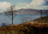
After about a mile, the way returns to the riverside and, although the water can be heard down to the left, it is difficult to make out the river because of the dense woodland and vegetation on the steep slope below. The track soon dips, however, taking you down to water level and offering excellent views back to Loch Rannoch and the mountains beyond. But, as usual, what goes down must come up and there's a healthy climb from here to the top of the track with tree roots to negotiate. The waymarked route turns left here, a path dropping down to cross a bridge over the burn. But we carry on up the track to a crossroads a few yards on.
At the junction, turn right and follow the track north past a lochan wedged in amongst the trees on the left. Carry on along the track as it curves left for a lovely strip of descent. Ignore the first track you pass on the right and continue until you reach a Y-junction at the bottom of the hill. The track forks five hundred yards on. Take the right hand option and go down to a concrete girder bridge over the Dall Burn. Cross and the track rises to the right to reach another junction just a few yards on where a path branches off to the right. Ignore this, bear left and continue up the track to a T-junction at the top of the hill.
Do another left, and the track climbs steadily round the long flank of the hill. It's a long pull but two miles from the junction, the worst is over and there's another lovely long descent to savour. Carry straight on down to a bridge over the Allt Camghouran.
There's a high locked gate at the bridge and the only way round it is to climb over. Then turn right and a farm track follows the burn north over open fields. These are often used for sheep grazing. There's a low gate a few yards on and a few more gates to pass through as you drop down towards the loch. Continue past several farm buildings to join the public road beyond the last in this string of gates.
Back on tarmac, turn right, crossing the Allt Camghouran once again, and follow the road east along the south shore of Loch Rannoch. It's a fairly flat hike and do watch out for traffic on this narrow minor road. The loch is never more than a few feet away and it's pleasant to stop occasionally and sit by the water.
Three miles on, the road kinks past posh Rannoch School and there's a public telephone box if you should decide 'it's good to talk' at this point. Why they need a call box here, given that most of the inmates were probably born with mobile phones ready attached, is a mystery. Another mile takes you back to the Rannoch car park and the end of the route.
WALK FACTS
Distance 14 miles/22km.
Maps OS Landranger 1:50,000 sheet 42 or 51 or Harveys Ben Lawers.
Start Forestry Commission Rannoch car park (grid ref NN 617571).
Parking Free car park with public toilets and drinking water tap.
Grading Tracks through forestry and quiet country road along lochside. A long walk and a route also suitable for mountain bikes.