In search of a Superfortress
By Colin Hogarth
Legs weary after a hard day's trekking in the Arrochar Alps, we decided on some easy exploration for the second day of our recent foray into the Argyll countryside. We set out in search of the wreckage of a B29 Superfortress aircraft that crashed in the hills above Loch Goil a little over 50 years ago. As it turned out, blisteringly hot May sunshine made the adventure every bit as taxing as our scrambling over The Cobbler the previous day.
I'd first made the trek up to the crash site some 15 years ago as a teenager during a family holiday based at a chalet at the head of Loch Goil. I knew vaguely where the aircraft was, but not exactly, so a call home from the comfort of Callum's Bar in Arrochar the night before we set off was in order to establish its exact location.
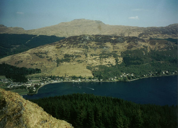
With a six-figure grid reference scribbled on the back of a beer mat in hand, we parked up at Corrow Farm and riding stables, a mile west of Lochgoilhead. From a gate at the back of the yard, a track zig-zags up to the foot of a firebreak in dense coniferous forest. This ride is the only way through the trees and it's a fairly steep ascent. The way leads up past an aerial and continues to a metal gate half way up break. From there the climb continues to the top of the plantation, below craggy outcrops. Due to the stifling heat - there was not a breath of wind in the sky - gaining height was a hard-fought battle. Eventually, however, we stood at the top of the ride and gazed down Loch Goil, the clear sky offering fine views over the glimmering blue ribbon of water.
From here we skirted left, following the top of the forest in a north-west direction. There were a couple of ankle-twistingly steep burn channels to negotiate before we reached the top corner of the plantation a kilometre on.
Here we spotted a shepherd across the hillside, a well-trained pair of collies marshalling his flock. Worried our presence may interrupt his work, we laid low for a while, soaking up the midday sun (a good excuse for a rest!). He called us over, but only to ask if we had seen any of his wooly beasts on our way up.
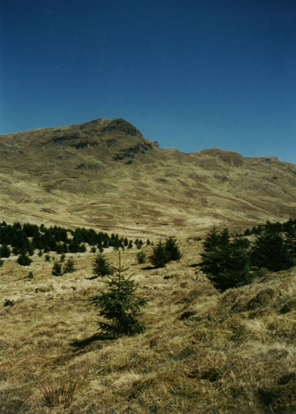
From the top of the forest, we headed due north up the slope towards the col between Stob na Boine Druim-fhinn and Beinn Tharsuinn (it's easy enough to identify on the map as there's a 508m spot height marked just east of the bealach on the OS Landranger series). As we climbed over the col a welcome breath of wind cooled heated brows and a small reedy pond provided a cooling drink for my dog. Less appealing, however, was the smelly carcass of a dead sheep!
From the top of the bealach we scanned the wide glen below to see if we could see any aircraft wreckage. Memories of my last visit were hazy, to say the least, but the layout of the valley itself did seem vaguely familiar. We plodded slowly down towards the grid reference point we had been given, but there was still no sight of what I remembered to be a fairly extensive area of remains. At one point Andy saw what he thought was a metal drum glistening in the sun on the slope to our left. He climbed up to ascertain exactly what it was, while I continued down towards a fence at the top of a fairly new area of forestry. It had not been there on my last visit and I was becoming increasingly concerned that the plantation may have obliterated the crash site.
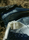
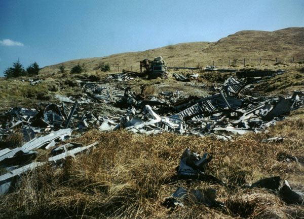
However, as I approached the fence I spotted a piece of tangled metal amid the young conifers. It was a welcome sight, confirming both my recollections and the validity of our grid reference. Hopping over the waist-high post and wire fence I saw other pieces of plane, leading to the main area of wreckage covering a piece of ground about the size of a tennis court. At the top of it all, a stone cairn has been built as a memorial to the 20 men who died when the B29 Superfortress came down on this lonely piece of hillside in January 1949. Much of it was as I remembered, although the rear gun turret I recalled sitting on the moor was no longer as it was - time had taken its toll. The crash site grid reference is NN 161022.
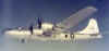
Developed by Boeing, the Superfortress was a "very heavy bomber". Work on the project began late in 1939 and the first one made its initial flight on September 21, 1942. However, in a bold wartime gamble, the American Airforce ordered the plane into quantity production months before this first flight. The plane's features included pressurized crew compartments, a central fire-control system and remotely controlled gun turrets.
Flying combat missions first from India and China and later from the Marianas Islands, the Superfortress repeatedly demonstrated its capability for carrying bomb loads of up to 20,000 lbs, against targets as far away as 1,500 miles from base. It had a 5830 mile range, a cruising speed of 220mph and a maximum speed of 365mph. Remains of the four mighty Wright R-3350-57 Cyclons 18-cylinder air cooled radial engines, which developed 2200hp each, are still to be found along with large sections of fuselage, wing and hydraulic wheel units. Amid the wreckage we found parts of the plane's electrical system, what may well have been a bit of an old glass Coca Cola bottle and, most interesting of all, a section of leather watchstrap.
I've made efforts to try and find out a bit about this particular plane's history, but so far all avenues have reached a dead-end. I can only speculate as to why the plane crashed here. Perhaps flying in mist or heavy cloud, the pilot may have been attempting to go over Beinn Tharsuinn, but mis-judged his height and flew into the ground around 100 metres below the col.
Alternatively, he may have come over from the east and clipped the hillside, sending the plane down. Then again, there may have been an engine problem. The compact nature of the crash site suggests the former as a likely option.
Leaving the crash site intact we re-traced our steps back to Loch Goil.
WALK FACTS
Distance 5 miles/8km.
Map OS Landranger 1:50,000 sheet 56.
Start Corrow Farm, near Lochgoilhead (grid ref NN 186004).
Parking There's space to park on a wide grassy roadside verge just south of the start of the track leading into Corrow Farm.
Grading A short walk with no real path over grassy hillside. Steep ascent at start. Dogs on lead due to sheep grazing.
Further reading For info on aircrash sites across Scotland (including grid refs) click here.