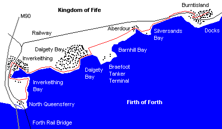
North Queensferry to Burntisland
By James Carron
The Fife Coastal Path is Scotland's newest long distance route. Once complete, it will stretch right the way round the kingdom's coast, from the Forth railway bridges up to the Tay road bridge. The route - which is fully waymarker - is largely finished and already attracting a steady stream of hikers. But if you don't have time for a lengthy trail, it's possible to do it in sections, thanks to the good local transport links.
The initial part from North Queensferry to Burntisland provides a cracking day out. While the route skirts by a number of fairly industrial sites, there is plenty of interest to keep your mind off these necessary economic intrusions.
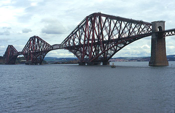
The Forth Railway Bridge - now over a century old - is a spectacular site, especially when viewed from the ground. You'll also see Inchcolm Island with its ancient abbey out in the firth. The muddy flats of Dalgety Bay are a haven for wildfowl and waders and patches of woodland along the way provide a home for a range of birds, butterflies and small mammals. If you're a sun worshipper, a particular treat is the award-winning Silversands beach at Aberdour. It is rated as one of the top bathing in Scotland thanks to the clean sand and quality of water.
Set off from the Waterloo Well in North Queensferry and the path follows the route of an old track up to disused quarries at Carlingnose where there are great views south over the Forth road and rail bridges and across the Firth of Forth to Edinburgh. A trio of islands - Inchmichery, Inchkeith and Inchcolm - are also visible. The way descends into a bay at Port Laing Beach and continues through woodland towards Cruicks Quarry, still used for the extraction of whinstone. The path turns inland at West Ness and a little further on you will reach Jamestone Pond, a pleasant spot amid this industrial landscape. Dragonflies are often to be seen flitting from plant to plant.
The route skirts the southern edge of Inverkeithing Bay to join the B981, which passes under the railway line and leads north into Inverkeithing. Wander through this historic town to the Mercat Cross, opposite St Peter's Kirk, and turn right here. The road leads to Ballast Bank car park and the way returns to the coast at Inverkeithing Harbour, by East Ness. Up until the mid-19th century coal from the pits of nearby Dunfermline was loaded on to boats here.
The path stays close to the shore from here to Dalgety Bay, arriving in a car park above St David's Harbour, another sheltered haven originally built to handle coal shipments from the Fife collieries. The path passes through patches of woodland beyond the harbour and soon reaches Downing Point where the remnants of First World War gun emplacements are to be found - a common feature along the south Fife coast. A short walk from here is Donibristle Chapel, where the Earls of Moray were laid to rest. Their grand home - Donibristle House - was located nearby although the site has more recently been converted into flats.
The path heads towards Dalgety Bay, turning inland to skirt round the back of this haven for wildfowl and wading birds where Shelduck, Dunlin and Terns can usually be seen. Half way round the back of the bay the path reaches St Bridget's Kirk. Here the route turns sharp left, passing through the trees of Ross Plantation, and then right again, heading inland to avoid the tanker terminal at Braefoot Bay. A good track passes a couple of small plantations and mast, and then passes under the road leading down to the terminal. It passes St Colme House on the right and then skirts the north side of Aberdour Golf Course before joining the A921.
Follow this east a short distance in to Aberdour and take the second road on the right, leading down to the harbour. The path rejoins the coast here, crossing Hawkcraig Point to reach Silversands Beach, one of the best bathing beaches on the east coast of Scotland.
Sheltered along stretches by old woodland, the path runs between the shore and the railway line for the final section to Burntisland, crossing the tracks by a bridge at Bendameer House, a mile on from Aberdour.
The approach to Burntisland is not the most attractive - the way running by an alumina works. The path curves left under the railway for a short detour to Rossend Castle, then heads east again, crossing the line this time to head in to the town centre.
WALK FACTS
Distance 11 miles/17.6km.
Maps Ordnance
Survey 1:50,000 Landranger sheets 65 and 66.
Start Waterloo Well, North
Queensferry (grid ref NT 132805). Finish Burntisland.
Parking Battery Road car
park, North Queensferry.
Grading Level coastal walk, track and path throughout.