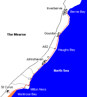
St Cyrus to Inverbervie
By Colin Hogarth
The charming coastal village of St Cyrus, perched on the cliffs above the sweep of golden sand buffering the sea in Montrose Bay, is the starting point for a gentle wander up the coast through old fishing communities to Inverbervie.
From the church in St Cyrus follow the track adjacent to it to the coast, pick up a path and turn left heading along the cliff top. Beyond a house the coastal path is signed. It remains on the edge of the cliffs and is a touch muddy and overgrown here, with a steep drop to the sea below, so take care.
The way descends to an old stone bridge over a burn and climbs steeply to a field. Skirt round the edge of the crops, passing above a castle ruin perched on a rock, and join a track at the far side.
Turn left here and, at a junction a short way on, go right, descending to the tiny hamlet of Tangleha', where small fishing boats rest on the grassy bank above the shingle. Pick up the beach here and walk north to join an obvious path leading by a caravan park perched just above the shore. Cross the next burn at a bridge and continue round the bay, towards a concrete look-out post perched on the slope above.
Beyond this war-time relic, the way passes by Seagreens and continues up the coast, running through a deep crack in the rock to reach a neat, white-painted cottage at Narrows. From here a track leads into Johnshaven. The road reaches the old harbour where a handful of small pleasure craft now take the place of the once thriving fishing fleet. There are still working boats here, but nothing on the scale seen during the heyday of the industry.
From the harbour, head straight along the road between neat cottages and sheds to emerge on to the coast at a small landscaped area of seating. Stay with the shore road as it leaves the village and passes by the front of a caravan park and, at the end of the tarmac, a wooden gate is reached. A track continues up the coast, running past the grounds of Lathallen School to a small encampment and, beyond this, fields of pigs.
After crossing a bridge over the burn at Haughs Bay, the way arrives at a cluster of cottages at Haughs of Benholm. Carry straight on, following the grassy track by open fields to Gourdon.
The track skirts between the beach on one side and a row of cottages to reach Gourdon harbour, another haven from the ocean used predominantly by yachts, pleasure craft and small creel fishing boats.
Like Johnshaven and many other towns on the Angus and Mearns coast, Gourdon was built on the fishing industry. The two communities are unusual in that they employed line rather than net fishing techniques.
From the harbour, the route twists through a narrow street of cottages and sheds, emerging into open country once again at Horse Crook Bay. Follow the track round the coast to reach Bervie Bay, a mile on, and Inverbervie.
WALK FACTS
Distance 9 miles/14km.
Map OS Landranger
1:50,000 sheet 45.
Start/parking St Cyrus.
Grading An easy, low level coastal
walk. Care is needed on the first half mile of the route from St Cyrus as the
path is narrow and there is a steep drop. This is a linear walk and there's a
regular bus service for the return to St Cyrus.